Arkansas Waterfalls
46
Arkansas is home to many waterfalls, including many of my favorites. The waterfalls in Arkansas are easily some of the greatest in Middle America, but there's a catch: just about every one will only flow good right after rain, and many will never flow in the summer, even after rain! But when it rains in Arkansas, it pours, and if you can get here after a good rain in the winter or spring, you'll see the sights of wonder that I have. Arkansas has a rather undeveloped trail network, so many of the waterfalls here require bushwacking to get to. Due to this, many of these waterfalls are not very easy to get to. Regardless, there are still some easy ones, and Arkansas in general is a nice place to travel through. I cannot reccomend the book "Arkansas Waterfalls" by Tim Ernst enough; it is an absolute masterpiece, and a must have for anyone wanting to explore the many waterfalls in this state. Not only has Mr. Ernst been discovering waterfalls in Arkansas for decades, but he's made a detailed book on how to get to them. Many of the falls that he found initially had no trail to get to, but over the years, trails have developed due to the increased foot traffic, and none of this would be possible without his hard work. We need a lot more people like Mr. Ernst in this world. I have divided the regions here in the same way as in Mr. Ernst's book, as I feel like it makes the most sense.

Buffalo River Area
The Buffalo National River and surrounding area is a fantastic area to visit with a high density of waterfalls (more still to come). Some of these take a ton of rain to look their best, so save this area for the rainy season (winter/spring). The falls listed here are all part of the Ozarks, but are also part of the Buffalo River watershed, whereas falls listed in the next section: Ozarks, are not part of the Buffalo River Drainage.
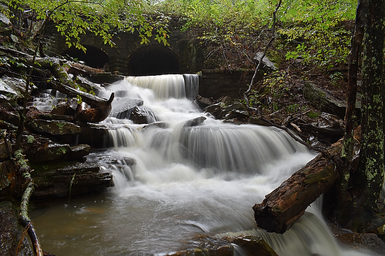
Eden Falls and Lost Valley 53'
Description: Get ready for a long one here, as this is one fantastic area. The crown jewel of Lost Valley is Eden Falls, but there is so much more to it than that. The height provided is for Eden Falls only. The other two are each roughly 10 feet tall. I'll keep this description brief, as it will make more sense to describe these wonders in the hiking description.
Hiking Description: Start at the large parking area for the Lost Valley Trailhead. Hop on the wide trail and after just a minute or two you'll reach the old parking area, with bathrooms and picnic tables. Here's where it gets interesting-the trail will come to Clark Creek, and you will have to ford this creek. If you visit during high(ish) water, as when I did, this is a rather tricky ford (not to mention the water was cold as it was December). Providing you make it across, the hiking is very easy for the next while. Eventually, you will reach a trail split. You could go either way, but I would recommend going right, and coming back from the left. Presuming you head right, the trail will get more rugged here, but stay moderately easy. After about five minutes, you will come to the natural bridge, which has a waterfall coming out of it. This is Clark Creek here. This is a very scenic area here, so be sure to enjoy it. Moving further down the trail, you will ascend some stairs and continue along the rugged and wild Clark Creek gorge. After a while you will reconvene with the split off trail, keep right. Shortly after this, you will see a massive undercut cave on the right called Cobb Cave, and see a massively tall, but not very powerful waterfall falling off the cliff. This weak falls must be over 100 feet tall, and was very impressive even with the weak flow. Just beyond this area a hundred feet or so is the magical Eden Falls. Wow! What a falls! Once you've thoroughly enjoyed Eden Falls, head back on the trail and when you get back to the split, you came from the left, and you could go either way, but I would recommend going right for one more surprise. The trail stays relatively flat for a bit, then begins going down a series of switchbacks. It was at the first switchback where I heard the sound of falling water off to the right. I followed a bootpath a hundred feet or so, and was greeted with a great waterfall with a twist-after it falls down, instead of moving further downstream, the water turns 180 degrees and goes behind the falls and falls into a cave! WOW! For this reason, I dubbed this waterfall "Labyrinth Falls". Anyways, if you continue down the trail, you'll go through some switchbacks, and eventually meet back up with the main trail. Keep right and you'll be trailhead bound.
Total Mileage: 2.3 total
Difficulty: 4/10 (Moderately Easy)
Date First Visited: June 8, 2020
Date Last Visited: December 10, 2022
Rank: A+


Natural Bridge (top left)
Eden Falls (top right)
Labyrinth Falls (center left)
Map of the area (bottom)
(Map credit to NPS; I edited in the location of Labyrinth Falls)

Labyrinth Falls
Hideout Hollow (2) 37'/9'
Description: Hideout Hollow is a neat place that takes a lot of rain to get it flowing good. It takes so much rain, in fact, that I never figured I would ever go here, because it would be such a rare event. Well, imagine my surprise when I see that most of Arkansas is about to get a "once-in-a-generation" flood, so I decided to check it out. The area was in a flash flood warning, and the rain was still falling when we were driving down the road to the trailhead, which is quite near to the famed Hemmed-In-Hollow. About a mile shy of the trailhead, the road was blocked by a deep pool of both moving and stagnant water, about five inches deep. We parked here, and walked the last mile. What follows is quite possibly the most surprising hike I ever did. The falls almost never flows, but we were greeted by a torrent, and if you want to see it like that, you're gonna have to come after six inches of rain have fallen and wade across TWO deep and rapidly flowing creeks, and it will not be safe. We honestly shouldn't have even tried to get to the falls in such conditions, but we did, and I suppose that's the price you pay to see something that no one else has! And after all that, when you get to the falls, you're only at the top, and getting to the bottom is tricky, and was surely a bad idea with all the flooding, but we did it anyway. More info below.
Hiking Description: Park here at a large, but unsigned parking lot: (36.073085, -93.265005). About a mile to the west of here, where the road passes by a pond, it may be flooded (this is the headwaters for the small stream that feeds Hideout Hollow). From the trailhead, the trail starts a slow downhill, winding throught the forest. At 0.2 miles, the trail crosses a small stream. This should be easy to cross, but at the time of our visit it was nothing short of a raging river! I honestly don't think it would have been possible to cross here, but about 100 feet upstream, the creek braided, and we were able to cross it in 3 seperate streams, instead of 1. This was still difficult, but it was possible. From here, the trail continues uphill a bit, then flattens and goes under some powerlines. When I was here, the entire trail had water on it, and if you come after a big rain, expect soggy areas at the very least. Near 0.75, you'll come to a wonderful overlook of the mountains and wilderness. You may be able to see the stream far below, too. Continue on the trail, which now follows along the top of this bluff. You'll come to the top of the falls at 1.0. The hike so far has been pretty easy, but you're probably wondering if you can get to the base. It is possible, but it's tricky, and you'd probably have to be a bit of a daredevil, too. Cross the stream above the waterfall (if it's flowing with any power, go well upstream before crossing). Once across, descend a short ledge of maybe 8 feet in height right next to the precipice of the falls. If you slip, you will fall 37 feet, and you might die. If you get onto this ledge, it's about 3 feet wide, and leads around to some nice views of the falls, before going under an overhang. This overhang is only 4 feet or so above the floor of the ledge, so you'll have to crouch/crawl your way along. It opens up after a few feet, and there is a place where someone has stacked up some rocks to make a step down from this ledge in a cut in the big bluff. From here, it's a steep descent down the hillside to the base, but it's easier and much less dangerous than what you've done so far. At the base, you can easily walk behind the falls. There was mist everywhere due to the intense spray of the falls, and the high water made it very surreal. We lingered here for quite a while. On the way out, be sure to check out a neat ~9' drop a few hundred feet upstream from the big falls. It's really easy to get to, and you can walk behind this one too! I've named it "Upper Hollow Falls" for obvious reasons. By the time we were finished at Upper Hollow, the rain had stopped and the creek crossings were much easier, and by the time we reached the car, that massive pool of deep water was completely gone! Only some small puddles on the side of the road remained.
Total Mileage: 2.0 total
Difficulty: 3/10 (Easy) to top of falls and to Upper Hollow, 9/10 (Difficult) to base of Hideout Hollow
Date First Visited: April 5, 2025
Date Last Visited: April 5, 2025
Rank: A+


Photos taken during a destructive flash flood; to see the falls like this is dangerous and extremely rare
Hideout Hollow (top), Jack behind Hideout Hollow (bottom left), Me behind Upper Hollow (bottom right)
Broadwater Hollow (2) 8'/21'
Description: There are two neat waterfalls found near the road on Broadwater Hollow Creek. Neither are very tall, but the area is scenic, and is worth a look if you're a real enthusiast. The upper drop is the small Paige Falls, which emties into a blue pool (muddied by rain during my visit), and the lower drop is called Broadwater Hollow Falls, and is taller, but really hard to photograph. The road to get down here is rough, so go slowly if you decide to seek this one out.
Hiking Description: There is some room to park on either side of the road here (36.105189, -93.267947). From the parking spot, continue walking down the road for about 200 feet and you'll come to Broadwater Hollow Creek. Cross the creek using the ford in the road, and then pick up a user trail headed downstream on your right. This trail is easy to follow to the top of Paige Falls, which you'll reach after less than five minutes of walking. To get to the base of the falls, continue through a really neat crevase between two massive boulders and on downstream. Not far from here, you'll see a bootpath going steeply down to the base of Paige Falls. There's a great view from the base, and the pool looked nice, even when it was muddied by recent rains. The taller lower drop is only about 100 feet downstream of here, and you can walk along the creekside to the top. There's a way to get to the base from there, but it's really steep and treacherous, and there might be an easier way down that I was unaware of. It might not be worth the trouble honestly, as it's a tough falls to get a good photo of, and looks best in higher water.
Total Mileage: ~0.4 total
Difficulty: 6/10+ (Moderate)
Date First Visited: May 26, 2025
Date Last Visited: May 26, 2025
Rank: A-

Paige Falls

Broadwater Hollow Falls
Triple Falls 48'
Description: My first visit to Triple Falls was in the summer of 2019, but this was before I got my camera, and was during low water conditions. I'd always wanted to return, so what took me almost five years? Answer: the road. The road down to Triple Falls might be the most notorious dirt road in all of Arkansas. In just over 2 miles, it descends over 1000 vertical feet of elevation, and most anyone that's been here would tell you to bring a truck or other 4x4. I've heard horror stories of people driving sedans down here, just to have to be towed out because they got stuck. So that's why it took me so long to get back: I had to wait for the perfect oppurtunity to get down here in the truck, which was not always avaliable for my use. But I made it! And it was awesome, let me tell you. The hike itself is only a few hundred feet, and is really easy. During leaf-out, you can actually see the falls from the parking lot. The road isn't actually that bad in a truck, just cool your brakes on the way down, and use the 4WD on the way out. I did it at 17!
Hiking Description: Park here (36.056610, -93.257609). The trail starts on the other side of the road, heading south. It stays right next to the creek, and you will come to the falls after 0.1 miles. The view is fantastic from trail's end, but I wanted to get a front on view, and waded out into the creek (photo below was taken in the middle of the creek). It was just 45 degrees outside when I did this, and my feet were numb, but it was awesome. I was able to wade very near to the falls, and what a view it was.
Total Mileage: 0.2 total
Difficulty: 2/10 (Easy)
Date First Visited: August 25, 2019
Date Last Visited: February 4, 2024
Rank: A+

Boen Gulf Polyfoss Area (4) 26'/33'/63'/27'
(including Magnolia Falls)
Description: There are four waterfalls in the upper reaches of Boen Gulf, and all four are well worth the effort of seeing. Magnolia Falls is quite popular and many people have seen it, but few continue on to the other falls. This is probably because they are harder to reach, and the trail isn't as obvious, plus some of the route has no trail at all! The classic route is to view Magnolia, then Woods Boys, then Dave Stahle, and end with Hadlock Cascade. They get progressively harder to reach, with Hadlock Cascade being quite difficult. More info in the hiking description. The heights listed are in the order in which I visited them: Magnolia, Woods Boys, Dave Stahle, and David Hadlock.
Hiking Description: Park roadside here (35.862801, -93.385118). There's plenty of room for a few cars and there's a sign for "Wilderness Access". The trail starts by heading northwest on an old road. It's easy to follow, but there may be water covering the surface. After 0.25 miles, cross a small stream, and then follow as the trail goes around to the left/west (an overgrown path continues straight). The trail narrows, but stays flat and easy, occoasionally going down some small hills. Continue past a historic rock wall on the right, and at 0.9 cross over a second small stream. Once you've crossed, LEAVE the trail to the left, following a user trail next to this stream. Before long, you'll have to cross this stream again, and you'll near Magnolia Falls at 1.0. It gets a bit steep to get to the base, but it's pretty easy really. There is a nice pool below the falls, and plenty of good wading oppurtunities if you'd like to see the falls from the other side (I sure did). From Magnolia Falls, you can walk downstream just 100 feet and peer over the top of Woods Boys Falls. Take a minute to appriciate the never-ending wilderness in the distance. There's no way to get to the base of Woods Boys from here, so return to the main trail, and turn LEFT, away from where you parked. The trail stays flat for 0.25 (1.35 from start if counting the split to Magnolia), before starting down a big hill here (35.868368, -93.399976). It's a bit steep, but the trail is in good condition. Just about 300 feet from the top of the hill, you'll reach the bottom of some bluffs (35.868889, -93.400500). The trail continues downhill to the right, but you will want to leave the trail to the LEFT and follow along this bluffline. There is no trail here, but the foliage is thin, and the walking is pretty easy. Just keep on following the bluffline, past some cool caves, and come to Woods Boys Falls 0.2 miles from the point where you left the trail (1.60 from start). The terrain gets rocky just before you reach the falls, so take care, but it's a lovely view once you get around some boulders. The next falls is Dave Stahle Falls, located on a side drainage of Boen Gulf, 500 feet to the west of Woods Boys Falls. To get there, cross the stream below Woods Boys, and scramble back up to the base of the bluffline (this can be tricky, but just hold on to rocks and tree roots as you go). Follow the bluffline for 500 feet, and you'll come to the narrow, but tall Dave Stahle Falls 1.70 from starting. The falls has quite a large undercut for its low flow. The very top of the falls is obscured from sight, but if you scramble down to the creek, you can see it clearly. Once you've had your fill here, retrace your steps to Woods Boys Falls, crossing back over Boen Gulf. This is where you'll need to decide if you want to see David Hadlock Cascade. The three falls so far have been a moderate hike to get to, but Hadlock Cascade is pretty tough. If you do decide to go, keep heading back in the direction you came from, but stray from the bluff a bit. The falls occurs a few hundred feet downstream of Woods Boys Falls, and there is a massive hill between you and the bottom. You actually passed Hadlock Cascade on the way in, but it's hidden from view if you stay near the bluffline. There's really no good spot to leave the bluffline and start down the hill, but we did so here (35.8664941, -93.4003634). which is about 500 feet from Woods Boys Falls. Just keep going downhill, around boulders, over logs, and through soggy and uneven terrain until you finally reach the creek below. From here, wade up the creek ~200 feet to the base of the falls. There are some small drops and rapids you'll have to maneuver around. From the base of the bluffline to the base of the falls is only a tenth of a mile at most, but it is difficult and tiring, so please be careful. This is a wonderful area, full of unique spots, and I hope you enjoy it as much as I did. Below are coordinates for each falls, as well as consolidated distances.
-
0.00 miles: trail begins on FR #6/NC #9050
-
0.25: cross small stream
-
0.30: trail turns to the left
-
0.90: cross second small stream, and follow it down to the left to the base of Magnolia Falls
-
1.00: Arrive at base of Magnolia Falls
-
1.10: Backtrack to where you left the trail
-
1.35: Top of big hill on trail
-
1.38: Below some bluffs, leave the trail to the left, following these bluffs
-
1.60: Arrive at base of Woods Boys Falls, passing by Hadlock Cascade on the way
-
1.70: Arrive to base of Dave Stahle Falls by following the bluffine past Woods Boys Falls (turn back after this)
-
You'll notice Hadlock Cascade is not mentioned here. That's because you could visit it before Woods Boys, or after, and it would throw off the mileage count. From the bluffline you follow to Woods Boys and Stahle Falls, it is 0.2 miles round-trip to get down and back from Hadlock Cascade. See coordinates below.
-
Magnolia Falls: (35.865389, -93.398389)
Woods Boys Falls: (35.865389, -93.398389)
Dave Stahle Falls: (35.865389, -93.398389)
David Hadlock Cascade: (35.865889, -93.400337)
Total Mileage: 2.0 total to Magnolia Falls, 3.6 total to see all four falls
Difficulty: 4/10 (Moderately Easy) to Magnolia Falls, 6/10 (Moderate) to Woods Boys Falls, 7/10 (Moderately Difficult) to Dave Stahle Falls, 9/10 (Difficult) to David Hadlock Cascade
Date First Visited: April 6, 2025
Date Last Visited: April 6, 2025
Rank: A+


From top to bottom, left to right:
-Map of the area
-Key
-Magnolia Falls
-Woods Boys Falls
-Dave Stahle Falls
-David Hadlock Cascade
Alum Cove Waterfall 18'
Description: Alum Cove is known for it's natural bridge, but during wet weather, a waterfall actually forms under the bridge. Very interesting indeed. Another wet weather waterfall can be found further along the trail, which I have been to a long, long time ago, but have no pictures of now.
Hiking Description: From the trailhead at Alum Cove, head out on the trail and you will reach the bridge after 5-10 minutes of walking. The trail goes over the bridge. From atop the bridge, you can look over to the right and see the narrow falls falling over the rock. What you probably did not see is the trail splitting off to the left just before the bridge. This will take you down to the base of the falls and under the bridge where the best views are. There are some rock stairs to make this easier.
Total Mileage: 0.6 total
Difficulty: 3/10 (Easy)
Date First Visited: Summer, 2019
Date Last Visited: April 25, 2022
Rank: A-

Fern Falls 42'
Description: Fern Falls is a fantastic waterfall that has a lot to love. The falls gets its name from hundreds of beautiful ferns that bloom in the spring and grow in the lush environment behind the falls. It's really pretty back there, and you can walk all the way behind the falls. The hike down here is pretty easy, and there is a lot to see once you get to the falls, so plan a visit. There are some soggy sections of this hike too, so plan to get wet. In years past, the trail was hard to follow in places, but due to increased foot traffic, there is a well defined path all the way to the base of the falls!
Hiking Description: Park in a large grassy area on the west side of Highway 7 here (35.892808, -93.190251). Look for a large sign marking the "Scenic 7 Byway". If there's been rain lately, it can be pretty soggy here, so be careful when parking. The trail starts behind the byway sign, and there will probably be some standing water here you'll have to walk through. Cross a powerline clearing, and follow a wide trail into the woods, headed west. You'll be following near a small stream, and the area is very wet and soggy, but it's mainly flat and easy to follow. After a little while, things will dry out, and after 0.25 miles, the trail turns to the north, and starts down a pretty big hill. The trail winds its way downhill, eventually nearing East Fork Shop Creek, which is the stream the falls is on. The trail meanders downstream, following the creek, and you'll have to cross a small tributary at 0.5 (this is the stream that was flowing over the trail at the very beginning). The trail stays flat for a while, and it will let you out at the big creek at 0.65. From here, you have a couple of options: #1 is to continue following the creek downstream a short distance, across another small tributary and past the top of the falls and to a great "eagle's nest" view from above (bottom photo). Option #2 is to cross the creek and follow the trail a few hundred feet downstream to an easy way to the base. I'd reccomend doing both. When you get to the base of the falls, you'll find that it actually falls in two steps, and you're at the base of just the first step. You can walk behind the falls here and appriciate all the ferns! It's a great view from there, but you can also scramble just a bit lower to the true base for another fantasic view. Lots to see here, and a great place to hang out, since there are tons of small boulders all around to sit on. The whole time I was here it was lightly raining, and the area felt tropical. It was truly a wonderful experience, and I hope you love it as much as I did.
Total Mileage: 1.5 total to base of falls
Difficulty: 5/10 (Moderate)
Date First Visited: May 26, 2025
Date Last Visited: May 26, 2025
Rank: A+


Falling Water Falls 10'
Description: Falling Water Falls is a great waterfall that is within eyesight of the road. Recent improvements have created some stairs down to the falls, eliminating the short scramble path. This is the only waterfall I have ever swam in, as there is an excellent swimming hole below the falls. I’ve been here many times, and I still need to get back here to get pictures during high water, as the falls take on a new look during different water levels. There really is a lot to love here, so plan a trip.
Hiking Description: No hike to view the falls, but there are two short staircases with one leading to the top of the falls, and the other to the base.
Total Mileage: N/A
Difficulty: 0/10 (Roadside)
Date First Visited: August 24, 2019
Date Last Visited: September 3, 2022
Rank: A

Six Finger Falls 6'
Description: Six Finger Falls is the distant relative of Falling Water Falls. They are on the same stream, yet are a few miles apart, and the road leading to Six Finger is a little rougher than the one to Falling Water. This falls is very close to the road, yet a bit of scrambling is still required.
Hiking Description: From the road near here (35.761558, -92.937123), head west through the trees on a boot path. They will lead down the hill to the falls. It’s a bit steep, but not too bad.
Total Mileage: <0.1 total
Difficulty: 4/10 (Moderately Easy)
Date First Visited: June 8, 2020
Date Last Visited: June 8, 2020
Rank: B+

Ozarks
There are so many waterfalls in the Ozarks, and they vary from roadside to difficult backcountry hikes. I've been to quite a few falls here, with still more to come. All the falls listed above are also in the Ozarks, but are found in the Buffalo River watershed. Some of the falls listed here are very close to falls in the Buffalo region, but flow towards other rivers. You could call this the Arkansas Great Divide, and it can be easily seen when you look at two places such as Magnolia Falls and Glory Hole Falls. They are only five miles away from each other, but Magnolia flows towards Buffalo River, and Glory Hole flows towards Big Piney Creek, and eventually into the Arkansas River.
Natural Dam 6'
Description: Natural Dam is a massively wide, but not particularly tall waterfall in extreme western Arkansas. You can see it from inside your car, and it’s a paved road all the way there (rare in Arkansas). If you're here after lots of rain, be sure to visit the nearby unnamed waterfall I've named "Little Natural Dam" at (35.647899, -94.394061). It is viewable from the highway. The photo below was taken after quite a lot of rain.
Hike Description: N/A
Total Mileage: N/A
Difficulty: 0/10 (Roadside)
Date First Visited: Fall, 2019
Date Last Visited: April 29, 2021
Rank: B

Natural Dam during high water
Little Natural Dam 4'
Description: This is a small waterfall visible from the road a short distance away from the more impressive Natural Dam. Worth a visit during high water.
Hiking Description: Viewable from the road. Coordinates for the falls: 35.647893, -94.394063
Total Mileage: N/A
Difficulty: 0/10 (Roadside)
Date First Visited: Fall, 2019
Date Last Visited: April 29, 2021
Rank: B-

Little Natural Dam during high water
Devil's Den 47'/56'
Description: Devil’s Den State Park is a very scenic park, and the Devil’s Den Loop Trail (which we will be using) is very nice. Visit after lots of rain for the best experience. There is more to see here than just this falls, so enjoy the place. Be sure to check out the dam located at (35.779536, -94.253269). Both pictures attached require scrambling to view.
Hiking Description: You could hike the whole loop, but the easiest way is to start from the north trailhead at (35.781291, -94.249510). From here, begin walking east on the trail (do not take the trail going south). You will cross a bridge over a tributary at about halfway in. The walking is pretty easy to the base of the falls. Stairs will take you up higher to a bridge over the left stream and then behind the right falls. Note that to get photos as seen here, some scrambling and bushwacking will be required.
Total Mileage: 0.9 total
Difficulty: 4/10 (Moderately Easy)
Date First Visited: Fall, 2019
Date Last Visited: March 17, 2020
Rank: A
Devil's Den during high water

The right falls

The left falls (part of it)
Road 299 Falls 21'
Description: Road 299 Falls is one of my favorite waterfalls in Arkansas. It's not very tall, and it takes a lot of rain to get it flowing, but I just found the setting to be perfect. It's far, far away from civilization in a maze of dirt roads, yet still easy to access. If the water is high, be sure to check out nearby Glory B Falls and Eagle's Nest Falls (next two entries).
Hike Description: Alright you've got two options here: for one, you could drive down Road 299 to within just a few hundred feet of the falls, or, you could park at the start of Road 299 and walk the road in. I say this because Road 299 is narrow and rutted, and it was a pleasant walk for me, so you make the choice. Even if you walk the road, it's only half a mile. Anyways, once you make it to here (36.256136, -93.656993) (estimate), you'll leave the road to the left on a series of bootpaths that lead down to the falls. If you've come after rain, you can hear the falls from the road, and a bit of quick exploration will show you how to get to the falls. It's not hard, but be prepared to ford the stream for the best views.
Total Mileage: 0.1-1.0 total (depending on where you park)
Difficulty: 3/10 (Easy)
Date First Visited: April 29, 2021
Date Last Visited: April 29, 2021
Rank: A+


Road 299 Falls during high water
Eagle's Nest Falls 41'
Description: Eagle's Nest Falls is a scenic falls to see during high water periods that takes some effort to reach. Access to the base of the falls in the immediate vicinity looked dangerous, and I had limited time, so only shot this falls from the "eagle's nest" view from above. Be sure to also visit nearby Road 299 Falls and Glory B Falls if the water levels are high.
Hiking Description: From the Kings River Overlook Trailhead, head out on the trail. If the water levels are up, you will quickly cross a small stream (no bridge). Continue on, and you will cross a second stream shortly. After this second stream, you should see a bootpath heading down on the right. Follow this path as it steepens and takes you to the eagles nest. Safely enjoy the view from here, as this is a dangerous area. I tried to descend to get a better view and nearly got ledged out, which frightened me enough to pack out with just this one photo. Take care.
Total Mileage: 0.3 total
Difficulty: 5/10 (Moderate)
Date First Visited: April 29, 2021
Date Last Visited: April 29, 2021
Rank: A

Eagle's Nest Falls during high water
Glory B Falls 16'
Description: Glory B Falls is an impressive roadside falls during high water. Very near to Eagle's Nest Falls and Road 299 Falls, which are also worth checking out in wet weather.
Hiking Description: The waterfall is within sight of the road and is easy to get down close to. Here are the coordinates of the falls: 36.196948, -93.690155
Total Mileage: N/A
Difficulty: 0/10 (Roadside)
Date First Visited: April 29, 2021
Date Last Visited: April 29, 2021
Rank: A

Glory B Falls during high water
Pig Trail Falls 18'
Description: Pig Trail Falls is a lovely roadside waterfall that only flows after heavy rain. The picture provided was taken after more than four inches had fallen. Turner Bend Falls (next entry) is just up the road, and worth a look if the water is up.
Hike Description: View from road at these coordinates: 35.646125, -93.839692
Total Mileage: N/A
Difficulty: 0/10 (Roadside)
Date First Visited: April 29, 2021
Date Last Visited: April 25, 2022
Rank: A-

Pig Trail Falls during high water
Turner Bend Falls 14'
Description: Turner Bend Falls is a nice falls really close to Pig Trail Falls that is worth seeing if the water is high. This photo was shot the same day as the picture of Pig Trail Falls, so you can see how these falls compare after the same amount of rainfall. It should be noted that the parking lot here (35.667499, -93.828222) is private property owned by the Turner Bend Store, and this parking is reserved for customers. Both times I've been here, I just went in and bought some snacks and then photographed the falls.
Hiking Description: From the parking lot, the falls is on the south side of the building. You should be able to see it from the road. Some bootpaths lead up for a closer look.
Total Mileage: <0.1 total
Difficulty: 2/10 (Easy)
Date First Visited: April 29, 2021
Date Last Visited: April 25, 2022
Rank: B+

Turner Bend Falls during high water
White Oak Creek Falls 37'
Description: White Oak Creek Falls is a wonderful open waterfall that looks nice in the sunshine. It'll be flowing when many other falls have run dry. The hike to get there is scenic and fairly easy, but you're going to have to get your feet wet. Don't worry though, as it's part of the fun.
Hiking Description: Start at the rather remote trailhead here (35.629938, -93.766699). There is a large dirt lot on the north/west side of the road, and the old road/trail starts across the street. The trail starts by going down a nice hill, then flattens out. After about 0.3 miles, you'll cross a small stream with a neat waterfall just below the trail. Continue on, crossing another small stream after just a few minutes. The trail ups and downs, before going down a longer hill and depositing you at the top of White Oak Creek Falls near 0.75. There's a good view from up there, but it's better from the base. There's an easy way to get down there, too! The old road/trail continues on the other side of the creek, so cross above the falls (careful!), and continue on the other side. Once across, the trail goes up a nice hill, then flattens out for a bit. After just a few minutes, the trail starts down a fairly steep and rocky hill, and then ends at the creek here (35.6277228, -93.7602093), ~0.85 from the start. From here, turn right and creek-walk upstream for about 500 feet to the base of the falls at 0.95. The creek is exceptionally scenic here and it's flat bottomed, so its an easy wade. The falls itself is quite impressive, as it falls directly onto flat rocks, and shoots outwards, instead of into a pool. Coordinates for the falls: (35.627458, -93.758028).
Total Mileage: 1.5 total to top of falls, 1.9 total to base of falls
Difficulty: 5/10 (Moderate)
Date First Visited: April 7, 2025
Date Last Visited: April 7, 2025
Rank: A+

Kings River Falls 10'
Description: Kings River Falls is a beautiful waterfall at the end of a great hike in pristine Ozark territory. Furthermore, this is one of the largest volume waterfalls in Arkansas, and will be flowing when many other falls in the area are dry.
Hiking Description: From the trailhead here (35.894553, -93.584981), head out on the trail going east. It's a very straightforward trail from here. There are no splits and no questionable areas, so just follow the trail for 3/4 mile and you'll be at the falls. Mere feet before you get below the falls, you'll have to cross a feeder stream that may require you to get your feet wet.
Total Mileage: 1.5 total
Difficulty: 4/10 (Moderately Easy)
Date First Visited: April 28, 2022
Date Last Visited: April 28, 2022
Rank: A

Sweden Creek Falls 81'
Description: Sweden Creek Falls is a tall and narrow waterfall with a massive alcove behind it that you can walk behind. It goes back 30 feet or more. The hike there is very rocky, but not all that difficult all things considered. You can get to the top and bottom of the falls, but I'm dumb and missed the trail split to the top. I found it on my way back to the truck, but it was getting late, so we decided to skip it. Many photos exist online of the view from the top.
Hiking Description: Park in the marked parking area here (35.969531, -93.452773), after a bumpy drive down a gravel road. Head out on the trail, which heads west away from the parking lot. It is marked in light blue blazes. It is a slow and steady descent for the first half a mile, which I didn't even notice on the way down. I sure noticed it on the way out! Around 0.5 miles, the trail will get a bit steeper, and you should hear the sound of water. This is not Sweden Creek Falls, but rather a tributary which falls over a cliff you have neared. Things get a bit confusing here, as I was under the impression that you crossed this small stream. INCORRECT! The trail turns hard left, and then splits. The trail to the left/straight stays above the bluff and goes to the top of the falls, continuing the light blue blazes. The trail to the right leads steeply down below the bluff in a cut in the rock, now marked in dark blue blazes. This area is pretty confusing, so consult the map below (it is simplified, but should be sufficient in getting you there). We went on the route to the base only, but if you have time, you should do both. Continuing down, the trail is quite steep and sloppy for about 50 feet cutting down throught the bluff. Once below the bluffline, the trail turns left, following the bluffline. From here, the hiking is very rocky, but is overall not too bad save for a few technical spots. You will pass by some fantastic rock formations in this bluff, including some caves. The sound of Sweden Creek can be heard far below on your right, but I couldn't see it. At around 0.8 miles, the falls will come into view as the bluff you've been following wraps around the spine of the falls. The alcove behind the falls is massive, probably the second largest I've ever seen, only after Yahoo Falls in Kentucky. A strange occurance of karst topograpy occurs here, as the creek dissapeared underground just after the pool below the falls. I'm not sure if this always happens, but it was when I was there.
Total Mileage: 1.6 total
Difficulty: 6/10 (Moderate)
Date First Visited: February 4, 2024
Date Last Visited: February 4, 2024
Rank: A+


The Glory Hole 31'
Description: The Glory Hole is unusual in that the water has drilled a hole through the bluff and it falls straight through. It's a very interesting spot for sure, and it's become one of Arkansas's most popular waterfall hikes. The hike to the top is pretty easy, but getting to the bottom requires a bit of scrambling.
Hiking Description: Park on the side of AR-21 here (35.828404, -93.390404). It's not marked, but there may be plenty of cars parked here. The trail starts as an old road, going down a hill. It flattens, and the hiking is uninteresting for a while. Near 0.35 miles, the trail splits. Follow the more obvious trail to the right. There are no markings here, but it should be pretty obvious. The trail starts going on a more steady downhill, and crosses a small stream at 0.65. This is the stream that feeds the big falls. The trail wraps around to the left, and passes by the top of an unnamed 10 foot drop on this stream. Pretty interesting spot, and you can even walk behind it. Continuing on the trail, it keeps going downhill, crossing another small stream at 0.8. Not far from here, this second stream converges with the other small stream you crossed, and fall into the Glory Hole at 0.9. You can look right into where the water falls into the hole in the rock (don't fall in!). From here, the official trail ends, but if you wrap around to the right of the falls and cross a third small stream, you can follow a well-trod path to the base of the falls. It's a bit steep and rocky, but it's not too bad. Come to the base of the falls at 1.0. You can easily walk behind it, and appriciate what a unique area this is.
Total Mileage: 2.0 total to base of falls
Difficulty: 6/10 (Moderate)
Date First Visited: April 6, 2025
Date Last Visited: April 6, 2025
Rank: A+


Pam's Grotto 37'
#8
Description: Pam's Grotto is one of Arkansas's finest waterfalls, but it takes a lot of rain to make it look its best. My photos were taken during a flood. The hike to the falls is short and scenic, but it's pretty technical, hence the high difficulty rating. The falls is named after Tim Ernst's wife, Pam, and what an honor it must be.
Hiking Description: Park in a small dirt pull-off next to AR-123 here (35.680244, -93.251726). The parking spot is on south side of the road, and the trail begins across the street on the north side. It goes up a small hill and into the forest, where you can see the small stream down on the left. Before long, the creek disappears from sight as the trail wraps around to the right, and begins climbing steeply uphill. It's pretty tiring, but the trail is in good condition. After 0.25 miles, the terrain flattens as you come to the base of some massive bluffs. Keep LEFT, following this towering and scenic bluffline. From here, the path is less obvious, but it doesn't matter because it's easy to follow along the base of the bluffs. Just keep going, and take note of how amazing the scenery is here! Near 0.45, you'll begin to near the creek again, far down on your left. You may see the falls in the distance, and you should also see the big hill in your way. Stay near to the bluffline, picking your way down the hill the best you can. It's very rooty, so there's plenty of trees to hang on to. Once near creek level, you'll have to make your way through some massive boulders, including a very tight spot where I could barely even fit through with my backpack on. It's a fun adventure to get through the boulder field, and once you do, WOW! Pam's Grotto is amazing! You can easily walk behind it, and right up to the very base. I love the way the water emerges from a narrow canyon and fans out to its base. Of the 15 falls I saw on this fateful trip (including some real beauties such as Hideout Hollow, Magnolia Falls, The Glory Hole, Cedar Falls, and more), Pam's Grotto was my favorite, and if you visit in high water it won't be a mystery to find out why.
Total Mileage: 1.0 total
Difficulty: 8/10 (Difficult)
Date First Visited: April 5, 2025
Date Last Visited: April 5, 2025
Rank: A++


Photos taken during very high water
Haw Creek Falls and Pack Rat Falls (2+) 6'/24'
Description: Many people have seen the short, but scenic Haw Creek Falls, but many less visit Pack Rat Falls, which is just a quarter mile away! It's tucked away on a tributary to Haw Creek, and except for some occasional bootpaths, there is no trail and you just have to follow the rocky stream all the way to the falls. It's a bit difficult, but it's not very far, so you can decide. There is another falls above Pack Rat Falls, but it is really diificult to get to, and I didn't attempt it.
Hiking Description: For both falls, park in the signed Haw Creek Falls Campground. There is a ford where you drive in, and if the water is up, you should not drive across (you might not be able to walk across either). It's only a bit of extra walking if you park before the ford. Either way, navigate to the north side of the campground and there are some short trails the lead down to Haw Creek Falls. It's almost roadside. The falls will be flowing most of the time, but it's really a treat when the water is up, and the width of the falls grows. To get to Pack Rat Falls from here, head to the east edge of the campground and hop on the Ozark Highlands Trail (35.6766805, -93.2546957). Hike the OHT for 200 just feet or so, where you come to a stream. Don't cross, but head upstream, staying on the right side if looking upstream. There's an obvious bootpath at first, but soon, you will have to cross the stream, and there won't be much of a path afterwards. Just keep going upstream, crossing the stream when necessary, and you'll come to Pack Rat Falls 0.25 miles from the OHT. The falls plunges into a beautiful blue pool, and you can walk behind it too. It's a very cool spot, and paired with the powerful Haw Creek Falls, it is a must-see!
Total Mileage: >0.1 total to Haw Creek Falls, 0.5 total to Pack Rat Falls
Difficulty: 1/10 (Very Easy) to Haw Creek Falls, 7/10 (Moderately Difficult) to Pack Rat Falls
Date First Visited: August 24, 2019
Date Last Visited: April 6, 2025
Rank: A+


Haw Creek Falls

Pack Rat Falls
Highway 123 Falls 47'
Description: Highway 123 Falls is a low volume waterfall that is close to a state highway (123 no doubt) and moderately easy to get to. Some light bushwacking and boulder scrambling is required to get close to the falls, but a faint trail is emerging. 2025 UPDATE: I got back here during flood conditions and saw the falls flying! I would highly recommend this place if the water is up, and you could easily pair it with nearby Pam's Grotto.
Hiking Description: From the large dirt parking area located here (35.619674, -93.291701), head across the street and pick up a boot path following a stream headed east. You’ll be on the left or north side of the stream, and you’ll just want to pick your way upstream the best way you can. You should come to the falls shortly. You can see it from the road in leaf-out.
Total Mileage: 0.2 total
Difficulty: 5/10 (Moderate)
Date First Visited: September 2, 2020
Date Last Visited: April 5, 2025
Rank: A
_4_JPG.jpg)

September, 2020 (above)
April, 2025 in very high water (below)
Longpool Falls (2) 8'/44'
Description: I had been wanting to go to Longpool Falls for a long time, and I was quite excited when I finally got the chance. I was even more excited when I saw that the 8 foot tall lower falls was flowing nicely. The hike to the lower falls is an easy one along an old road. The big 44' upper drop is only 500 feet upstream from here, but there is no trail, and there's some tricky boulder scrambling to get there. It's a wonderful waterfall though, well worth the trouble, and it's yet another in Arkansas that you can walk behind.
Hiking Description: The old road that you'll use as your trail starts here (35.546791, -93.160059). This is just before the payment station, and there is nowhere to park there, so continue on a short distance. Pay the $3 day-use fee, and find a place to park near the entrance area. Once you've parked, backtrack to the trail. It goes up a short hill, then flattens and enters a small clearing. Once back in the forest, the trail stays easy and mainly flat, occasionally going down a small hill. Keep on going until you come to a creek after about half a mile of hiking. You should see the lower falls off to the right. To get closer, cross the stream, and walk up to the base of the lower falls. This is all easy. To get to the big drop, continue up the left side of the stream (if looking upstream). There isn't much of a path, and you'll have to do some scrambling. Some of it is pretty tough, and it's difficult to stay near to the creek with the rugged terrain. It'll be slow going, but you should come to Longpool Falls at 0.6. You'll likely still be on the left side, but you can walk behind the falls to the other side for even more great views. There's a spot where you can lookout at the falls and see the bluffline wrap around (see photo below), and it's pretty amazing. Coordinates for Longpool Falls: (35.549235, -93.152348).
Total Mileage: ~1.2 total to see both falls
Difficulty: 3/10 (Easy) to the lower falls, 9/10 (Difficult) to Longpool Falls
Date First Visited: April 6, 2025
Date Last Visited: April 6, 2025
Rank: A+

Lower Falls

Longpool Falls
Arkansas River Valley
Nestled between the Ozarks to the north and the Ouachitas to the south, there is a large river valley carved out by the Arkansas River in the west-central part of the state. You won't find any waterfalls in the valley itself, but rising up from the valley are tall mountains, including the tallest in Arkansas: Mount Magazine. These mountains are not considered part of the Ozarks, nor the Ouachitas, so another region is in order. There are some nice falls here, including what just might be the most famous waterfall in all of Arkansas: Cedar Falls.
Hardy Falls Complex 8'+
Description: Ok, this is a confusing one. Most sources online will show you one falls when you search for Hardy Falls. I quickly found six waterfalls in the immediate area, and there are likely more down the mountain. This will get confusing real fast, so be sure to take a look at the map I provided. I will list these falls in the order I visited them. Also note that the only officially named falls here is the main Hardy Falls, and all the others are just basic names I gave them for simplicity. Visit after lots of rain! Hardy Falls proper is 8 feet tall and none of the others are more than 20 feet tall, and I don't have measurements for them.
Hiking Description: You'll want to park on the side of the road in the hairpin turn here (35.151425, -93.562859). Side Falls will be right here, and is clearly visible from the road. This is the only falls here that is not on the main creek. Moving a hundred feet or so to the west, you'll see Hardy Falls down on the right. Getting down to the falls is pretty easy. The classic view is from under the arch bridge, which will require some wading. Next up is Turn Falls and Woods Falls, which some may consider just one falls. These are found a short distance upstream of Hardy Falls, and requires some light bushwacking. This is as far as I went upstream, and the next falls I saw is downstream of Hardy Falls. I went under the road following the culvert and picked my way down the side of the stream. This next falls I named Bridge Falls, and you can see that we're just downstream of the falls. The terrain is getting rough at this point, and the hardest falls to get to is next downstream, which I named Rocky Falls. Notice you can still see the bridge in the background. Judging on the nature of this stream, there are probably more waterfalls below this, but this is as far as I went.
e
Total Mileage: Varies
Difficulty: Varies (Roadside/Easy/Moderate)
Date First Visited: September 2, 2020
Date Last Visited: September 2, 2020
Rank: Unranked
all photos taken during high water

Side Falls

Hardy Falls

Turn Falls (front) and Woods Falls (back)
Bridge Falls

Rocky Falls

Mount Nebo Falls 32'
Description: Alright, here’s the most shocking image I have to show on this entire website. I visited Mount Nebo Falls in September, when it would usually be a mere trickle, but I was here after a mind-boggling 8+ inches of rain. Yes, EIGHT inches of rain. Good luck finding an image anywhere on the internet of this falls with more water. I’m telling you this for two reasons: #1: it’s kind of an accomplishment for myself, and #2: if you choose to visit these falls yourself, it is unlikely to look like the photos shown here. Nevertheless, it is still a nice falls, and Mount Nebo State Park is a nice park too.
Hiking Description: From the Gum Springs Trailhead at Mount Nebo State Park, head out on the trail going west. You will be near the stream almost immediately, and will begin going down many stairs and will see the falls on the left. The further you follow the trail down, the more waterfalls you will see. When I was here, not only was the 8 inches of rain still falling, but it was flooding the trail, and a stream had formed ON the stairs we were walking down. It was quite surreal in the pounding rain.
Total Mileage: 0.3 total
Difficulty: 4/10 (Moderately Easy)
Date First Visited: September 2, 2020
Date Last Visited: September 2, 2020
Rank: A-

Mt. Nebo Falls during very high water
Cedar Falls 95'
Description: Cedar Falls is one of Arkansas's most famous waterfalls, and looks more like it belongs in Tennessee's Cumberland region than anywhere in Arkansas. It really is quite the sight. Many people talk of the difficult hike to the base of the falls, but it's really not that bad if you just take it easy. If you come when it's flowing, which is much of the year save for summer and early fall, it's worth the effort. 2025 UPDATE: I got here during higher water (still not flood stage), and me and Jack got all the way behind the falls and WOW! There was so much mist that to look up at the falls was like to look up at the sky during a downpour. Highly recommended.
Hiking Description: Start your hike at the Mather Lodge. Walk into the building and then out onto the patio-this is where the hike starts. You can ask someone working there if you can't find the trailhead. Once outside, you will see how high up you are, as you can see for miles. Once you're admiring the view, start descending into the gorge. It's a half a mile of rocky and steep downhill until you meet Cedar Creek at a large footbridge. Cross the bridge and turn right. From here, it's another half mile of hiking to the falls, much flatter than the first half, but still very rocky. Once you arrive, you'll be glad you came-this thing is massive! If you're up for a challenge, you can scramble around the edge of the pool all the way to the base of the falls. It's slippery and steep in spots, but it's the view of a lifetime from back there. You can also view this falls from the Cedar Falls Overlook, located a short distance east of the Mather Lodge (at a separate parking area). This trail has disabled access and is short.
e
Total Mileage: 2.0 total
Difficulty: 6/10 (Moderate)
Date First Visited: April 24, 2022
Date Last Visited: April 7, 2025
Rank: A+


View from base (left)
View from overlook (right)
Jack behind the falls (bottom)
_JPG.jpg)
Ouachitas
While not as often talked about as the Ozarks, the Ouachita Mountains in southwest Arkansas are very scenic, and hold a few nice waterfalls. I've only been down there once, and the water levels were pretty low, but it was still nice. Lots of great wading oppurtunities here as well.
Little Missouri Falls 15'
Description: Little Missouri Falls is a nice waterfall that has a short, easy hike, after a long, bumpy journey down gravel roads. Great wading opportunities too.
Hiking Description: Start at the Little Missouri Trailhead here (34.422706, -93.919568). Head out on the concrete trail, and shortly come to a bridge. After crossing the bridge the trail gets a bit rougher, but quickly you will come to the the first of two staircases which lead to viewpoints of the falls.
Total Mileage: 0.2 total
Difficulty: 3/10 (Easy)
Date First Visited: April 23, 2023
Date Last Visited: April 23, 2023
Rank: B

Crooked Creek Falls 16'
Description: Crooked Creek Falls is a nice waterfall very near to Little Missouri Falls, and is visible from the road. Bootpaths lead closer to the falls.
Hiking Description: The falls are located here (34.427061, -93.885630), and there is room to park along the road.
Total Mileage: <0.1 total
Difficulty: 3/10 (Easy)
Date First Visited: April 23, 2023
Date Last Visited: April 23, 2023
Rank: A-

Falls Branch Falls 12'
Description: Falls Branch Falls is a classic in Arkansas, and while not very large, it is scenic, and you can get right up next to it. Furthermore, the hike is easy, and there are great wading opportunities at the falls.
Hiking Description: Start at the Falls Branch Trailhead here (34.431405,-92.913513), head out on the trail going south. Follow the signs for the waterfall, and you will stay near to Lake Catherine most of the way. After about 10 minutes of walking, the trail will start heading up a cove in the lake, and this becomes Falls Branch. The falls will come into view shortly.
Total Mileage: 1.4 total
Difficulty: 3/10 (Easy)
Date First Visited: April 23, 2023
Date Last Visited: April 23, 2023
Rank: A-

