Waterfalls in New York
68
New York is one of the best states for waterfalls, and I'm saying that after only visiting the state a few times. Keep in mind that there are many, many waterfalls in New York not listed on this site (yet), and a great resource for finding falls here is the book New York Waterfalls: A Guide for Hikers & Photographers by Scott E. Brown. Even if you don't visit any of these falls, this is a great picture book, and from time to time I enjoy just looking through the wonderful pictures even when I know I won't be going there anytime soon. There are many more waterfalls that are off the beaten path in New York that aren't featured in that book, and I will hopefully have them all documented right here, but that will take many years, maybe even a lifetime, so we'll see. There are waterfalls in every part of this massive state, and the ironic thing is that the area with the fewest waterfalls is far-western New York, where Niagara Falls is. Another great thing about New York waterfalls is that many of them are in very nice parks that make the otherwise treacherous landscape easy to traverse. Subregions are listed generally west to east. Enjoy this wonderful state!

Western New York
Western New York includes all the waterfalls in the far western side of the state, bordered by Canada and Lake Erie to the west, and the Genesee Valley region to the east. This area of the state does not have very many waterfalls, but there are some nice ones. This is also where Niagara Falls is located (not documented yet), and that's plenty large.
Hobuck Flats
Description: Hobuck Flasts is a public fishing area and park with a very nice waterfall that is somewhat off the radar. The only catch is that the drainage feeding the falls is very small, and will only flow well during the spring and after rain. The hike is short, but still very scenic.
Hiking Description: Park here: (42.699388, -78.940668). Head across the large bridge over Eighteen Mile Creek. The creek is very beautiful here, but on my visit, it was not flowing very heavily, and I was honestly expecting the falls to be a bust. I continued on however. The trail stays near the large creek, and after 0.15, there will be a trail split marked by a red, white, and blue colored post. Keep right, staying level with the creek. The trail narrows, and there is a drop-off towards the creek, so be careful. Just a few hundred feet further, there is another trail split. This time, go left, following a small tributary. This is the stream the falls is on, and you will come to the falls at around 0.2. I was baffled to see it actually flowing! The trail turns hard right, and crosses over the stream on a small bridge. From here, you can go left to a large, open viewing area to enjoy the falls.
Total Mileage: 0.4 total
Difficulty: 2/10 (Easy)
Date First Visited: October 15, 2024
Date Last Visited: October 15, 2024
Rank: A-

Eternal Flame Falls 23'
NEW!
Description: Eternal Flame Falls is a small waterfall with a big story. Behind the falls is a small opening where natural gas is emitted, and a continuous flame burns there. It originates deep underground, and just so happens to emerge right here next to this falls. The flame occasionally goes out, but it can be started up again with a lighter. It's very unique indeed. As for the falls itself, it's a small cascade that can dry up, but if you visit after rains, it can make for a very pleasing photo. I was here 2 days after heavy rains dropped 3+ inches in the area. The hike down here is short, but rugged. The scenery is superb though, and worth the trouble.
Hiking Description: There are multiple places to start your hike, but the easiest is from Chestnut Ridge Park here: (42.702087, -78.747861). Head west on the wide dirt trail, which soon enters a beautiful forest. There will be some trail junctions near the start - keep straight at all of them, following the blazes that show a flame. After about 0.25 miles, you will find yourself high above the falls, and you may be able to catch a glimpse through the canopy. Keep on the trail, which stays flat and easy for a while, before starting down a pretty big downhill via many wooden steps. Once you're near creek level, take a left on the signed spur trail to the base of the falls. Head down a few more steps, and you will be in the gully! The gently flowing creek will be on your right, and you'll have to cross it almost immediately. The crossing should be easy. Continuing upstream, there isn't much of a trail to follow, so just stay in the creekbed, enjoying the terrific scenery! Looking upstream, the creek should be on your left, and you shouldn't have to cross it again. There may be some blowdowns to navigate around, so take care, but it will all be worth it when you arrive at the falls at 0.6. The flame is on the side you're on, and more great views are afforded if you cross the creek to the other side. Plan to spend some time admiring this beautiful spot, especially if the water is up and the flame is ablaze!
Total Mileage: 1.2 total
Difficulty: 6/10 (Moderate)
Date First Visited: April 2, 2026
Date Last Visited: April 2, 2026
Rank: A+

Glen Falls 30'
Description: Glen Falls is a large waterfall in a town park that has consistent flow, but isn't terribly scenic. I'm not sure what it was about this place, but I wasn't impressed.
Hiking Description: Park in a large lot here: (42.965718, -78.744626). From here, walk south a short distance to Glen Avenue. Turn right (west), following the sidewalk of the street. Cross over Elicott Creek on Glen Av., and then turn left and cross the street in a crosswalk. You've now entered Glen Park, and a paved trail wraps around a pond and over to the falls after 0.2 miles from where you started. The trail goes up some stairs to get to the top of the falls.
Total Mileage: 0.4 total
Difficulty: 1/10 (Very Easy)
Date First Visited: October 15, 2024
Date Last Visited: October 15, 2024
Rank: B-

Akron Falls 35'
NEW!
Description: Akron Falls is a waterfall that seems to have a problem with me. On my first visit in October, 2024, I was greeted with a dry falls. On my second visit in April, 2026, it was a flooded mess. And on my third and most recent visit later in that very same April, sunlight was an issue! All three times I've been here I've had some kind of trouble, and frankly, I'm about ready to give up on this one. The photo provided is from my last visit.
Hiking Description: Park here: (43.015277, -78.484851). You are already very near to the curiously named Murder Creek, and if you pick up the paved trail, it will take you down a few steps and right over to the falls.
Total Mileage: 0.2 total
Difficulty: 2/10 (Easy)
Date First Visited: April 2, 2026
Date Last Visited: April 2, 2026
Rank: B
_JPG.jpg)
Indian Falls 22'
Description: Indian Falls is a large waterfall that you can only partially view, but it is roadside, and I still enjoyed it. The viewing area is from the patio of the Indian Falls Log Cabin which is a restaurant. I'm not sure if they expect you to be a customer to use this deck, because when I was here, the place was closed. It looked like a fun place to eat though, if it was open.
Hiking Description: Park in the large parking lot for the restauraunt, located here: (43.026425, -78.399217). Walk over to the building, and the patio is right there, in front of the place.
Total Mileage: N/A
Difficulty: 0/10 (Roadside)
Date First Visited: October 15, 2024
Date Last Visited: October 15, 2024
Rank: B+

Medina Falls 40'
Description: Medina Falls is a large and powerful waterfall in the city of the same name. It has consistent flow year-round, so visit anytime. The falls is a bit of an engineering marvel, because Oak Orchard Creek flows under the Erie Canal, tumbling over the 40 foot falls very near to the canal itself. You can view the falls from the Erie Canal Heritage Trail, which is very easy. The trouble with this is that, in recent years, the view of the falls has been obstructed by foliage, and it's hard to fully appriciate it from the canal now. However, there is a better way, but it's a bit tricky to get to. More information below:
Hiking Description: Start at this unmarked dirt lot here: (43.222659, -78.382267). Walk down the small grassy hill to the Erie Canal and trail. Turn right (west), following the canal. Immediately, you will cross over Oak Orchard Creek, and you can see the top of the falls a short distance to your right. Continue a short distance further, and there will be a view of the falls through the trees. It's very obscured, as mentioned previously, but there is a way to get to the base. Keep walking to these coordinates: (43.2218929, -78.3839844). Once you get here, it will look completely unremarkable, but look to your right, over the guardrail of the trail. There is a ladder down there! This is your route to the base, so hop the rail, and descend down the short ladder. From here, a rough, but easily followed path heads rather steeply downhill. Quickly, it splits-keep left, going downhill still. You're getting close to the falls now, but you still have one more hurtle. The trail starts to get really steep, but luckily, someone has tied a yellow rope down this final descent. I cannot tell you how much easier this was made because of that rope. At the end of the rope, you're at the creekside, and the falls is just to your right. You can follow the rocky bank up closer to the falls, where there is plenty of mist. It's very beautiful down there, but it's hard to ignore this odd smell. This is likely from waste that gets dumped out of the Erie Canal and into Oak Orchard Creek, so I wouldn't wade here if I was you.
Total Mileage: 0.2 total
Difficulty: 1/10 (Very Easy) to the top, 7/10 (Moderately Difficult) to the base
Date First Visited: October 15, 2024
Date Last Visited: October 15, 2024
Rank: A

Genesee Valley
The Genesee Valley region of New York includes all falls in the Genesee River watershed, and this is where things start to get really awesome, really fast. There are some truly massive waterfalls here, including the five behemoths on the Genesee River. Furthermore, many waterfalls exist on tributaries, including some real giants. This region is bordered by the Western New York region to the west, and the Finger Lakes region to the east.
Hume Falls 27'
Description: Hume Falls is a beautful waterfall that is significantly off the radar. Very few people have been here, but it is a pretty straightforward hike there. It is almost directly under a road bridge, but there's no way to get to the base from there (believe me, I've tried). The proper way to access this falls is from parking at the Hume Highway Garage. I parked at the lot above the hill, but later found out that you can drive down this hill very near to Cold Creek (the falls is on this creek). The nearest you can park to the start of the hike is here: (42.468241, -78.131388). From here, you will follow the creek all the way to the falls, half a mile upstream.
Hiking Description: From the aforementioned coordinates, begin following the creek upstream, headed north. There's a large open plain on the right side of the creek here for a bit, but there are a lot of prickly plants here, so make sure you bring long pants, or you'll be hurtin' for certain. After about 500 feet, the plain will end, and there won't be much space left on the right side of the creek, so cross the creek here to the left side. It's an easy crossing, and on the other side of the creek, there's an overgrown path that follows the creek slightly inland. It's easy walking here. After a bit, the trail meanders closer to the stream, and you may have to enter it on occasion, but it's easy wading here too. Near 0.28 miles, the stream will begin a long left turn. When you're here, it looks like two left turns, but after looking at a map, it's more of one, long turn. Near this point, there won't be much of a trail to follow anymore, so just pick your way up the creek. I stayed on the left side, which got pretty rocky and slippery, and it may be better to cross over to the other side of the creek sometime after 0.35. This is also where you'll finally get to see the falls, but it is still pretty far upstream. Continuing up the creek, you will pass some 'Posted' signs on the left, and I believe these are here for the houses that are near the creek here. If you could get to the falls from here, it'd be so much easier! But alas, this is someone's home, so stick to the creek and continue on. The going is pretty slow here, but once you eventually reach 0.45, you will be getting very close to the falls, but there is a large, deep pool blocking your way. If you haven't crossed to the right side yet, you'll have to now. This is another easy crossing. Once across, continue upstream into a very sloppy section. You'll have to do some mild boulder scrambling, but the "sloppy" part is that they're covered in slick mud. It's not too hard, but just make sure you don't slip off into the creek. At 0.5, you'll arrive at the view pictured below, and it's very nice. You can climb up the lower section of the falls to get very close to the main upper drop if you'd like. If you do, you'll be right under a bridge, but there is no way to get up there! I was really hoping to find a shortcut back to the car, but no go. Check out the map below for more detailed information. Last thing I'll mention is that Cold Creek has a large watershed, and this picture was taken after just a bit of rain in a dry period, so it should be flowing most of the time.
Total Mileage: 1.0 total
Difficulty: 7/10 (Moderately Difficult)
Date First Visited: October 14, 2024
Date Last Visited: October 14, 2024
Rank: A+


Hume Falls
Wiscoy Falls ~35'
Description: Wiscoy Falls is a scenic roadside falls that has good flow year-round. Nearby to famous Letchworth State Park and seldom visited Hume Falls, so plan a visit. Park here: (42.504911, -78.082331). Walk just a few feet south to the road bridge over the creek, and look to your right to see the falls. A short trail leads to closer views of part of the falls.
Hiking Description: N/A
Total Mileage: N/A
Difficulty: 0/10 (Roadside)
Date First Visited: October 14, 2024
Date Last Visited: October 14, 2024
Rank: A-

Letchworth State Park Waterfalls (3+) 71'/107'/70'
#4
REVISED!
Description: There are three massive waterfalls in Letchworth State Park, as well as numerous smaller waterfalls that I have not been to. I will provide descriptions for the three that I have been to, which includes Upper, Middle, and Lower Falls, all on the Genesee River. Upper and Middle Falls are encountered very close together, while the Lower Falls is a few miles away and requires a drive from the other two. Also worth mentioning is Inspiration Point, which has clear views of the Genesee Gorge and Middle Falls in the distance.
Upper and Middle Falls:
The closest parking lot is located here: (42.581438, -78.045580), but if that's full, there are more parking areas a bit farther away. From the previously mentioned location, head out on the paved trail going southwest. After you've crossed the road, the trail will come to the river's edge high above, and you will arrive at the Upper Falls after only 0.1 mile. Quite the view here, especially with the railroad trestle as a backdrop. Once you're done here, backtrack to the parking lot, but continue on the trail, which parallels the parking lot and road. You will soon distance yourself from the road, but you will still be next to the river. Notice how calm it is here. After about .25 miles from Upper Falls, you will come to Middle Falls, and it is massive! The trail wraps around the side of the falls, offering fantastic views. Some stairs will take you down a bit lower and closer to the falls, but the best views are from before the stairs. Thouroughly enjoy Middle Falls, and when you're finished, backtrack to the parking lot, clocking in at 0.6 total miles.
Total Mileage: 0.6 total
Difficulty: 2/10 (Easy)
Lower Falls:
Park here (42.588170, -78.015995). The dirt trail heads west from here, passing the octagon shaped gift shop. After 0.1 mile, you will come to a trail split. The trail to the left leads down 127 stairs to the best views of the falls and the footbridge over the river. The right trail leads to an obstructed view of the falls without any stairs. I would recommend going left and descending the stairs to get the view pictured below.
Total Mileage: 0.5 total
Difficulty: 4/10 (Moderately Easy)
Date First Visited: October 24, 2021
Date Last Visited: April 4, 2026
Rank: A++

Upper Falls

Middle Falls
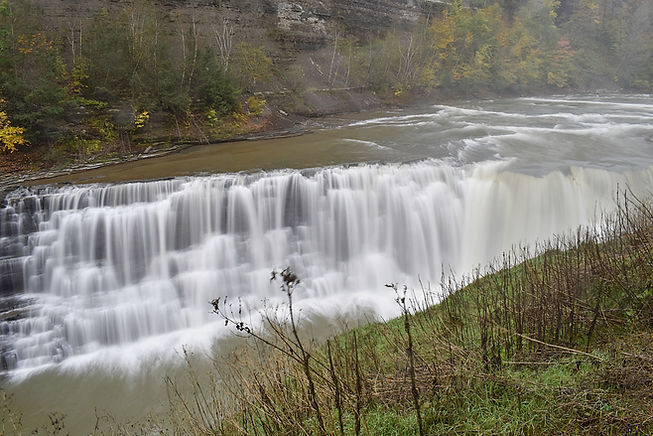
Lower Falls
Stony Brook State Park Waterfalls (2+) ~30'-~60'
Description: Stony Brook State Park is an amazing park that is definately worth a visit. There are three big waterfalls (two pictured), as well as many smaller waterfalls along the way. The entire hike is right along the creekside, and the scenery could not be better.
Hiking Description: Park here: (42.520874, -77.695009). From here, head east on the wide trail. Quickly you will come to the creek where it is dammed to create a swimming area. Turn right here, and the creek will soon become naturally flowing again. After about .25 miles, you will cross a footbridge over the creek. You will follow the creek as it goes around some turns. Notice it getting more turbulent as some small falls and cascades come upon you. Around .4 miles, you will come to a second footbridge, but before you cross, enjoy the small but very scenic unnamed waterfall here. If you continue across the bridge, you will see that the gorge walls are getting tall. Near .5 you will come to the stunning lower falls. Perfect views await you here. Continue up the stairs to the top of the falls past more great views. There's a nice small waterfall just above the lower falls. If you continue on just a short bit further, you will come to the middle falls, which is as wonderful as the lower falls. You can get very close to both falls and appriciate just how big they really are. This is as far as I went on the trail, but there is one more major waterfall upstream. I didn't visit because there is no developed access to it, and from what I've read online, it's pretty dangerous to get there.
Total Mileage: 1.1 total to Middle Falls and back
Difficulty: 4/10 (Moderately Easy)
Date First Visited: October 25, 2021
Date Last Visited: October 25, 2021
Rank: A++

Lower Falls

Middle Falls
Grimes Glen (2) 61'/60'
NEW!
Description: Grimes Glen is a magical place with two towering waterfalls. Much of the hike consists of creek-walking, but it's actually pretty easy. The scenery is amazing, too, as to be expected. These falls will be flowing for much of the spring, so when a warm day presents itself, seek out this terrific area!
Hiking Description: Start here: (42.615205, -77.413613). Begin your hike by following the wide, flat trail upstream along Grimes Creek. Within sight of parking, you will cross a footbridge over the creek, and the trail will continue on the left side of the stream (if facing upstream). Continue for 0.3 miles, where the well-defined trail starts to fade. You can get to within a few hundred feet of the first falls on this nice trail. Near the first falls however, you'll likely be pushed into the creek. Don't cross; just continue hugging the left bank. You may not have to enter the creek if the water levels are lower, but in any case it is shallow. Reach the first falls near 0.35. It is formed where Springstead Creek falls 61 feet directly into Grimes Creek. It is a very neat spot, as you can literally reach out and touch it - you're that close. If you're here for photography, note that you might have to cross Grimes Creek if you aren't working with a wide angle lens. Once you've had your fill here, continue following Grimes Creek upstream, staying on the left side. You will never have to cross the creek. Continue through some twists and turns, enjoying the magic as you go. Come to the second falls, this one on Grimes Creek proper, at 0.55. The shape of this falls is like nothing I've ever seen: The left side is a cascade, the right side is a slide, and cutting down the middle of it all is this strange spot where water is shot down and then hits a rock midway down and is propelled back into the air. You can get quite close to all of this since the pool is pretty shallow, and it is a true work of art. You really have to see it to believe it, and the pictures can't do it justice.
Total Mileage: 1.1 total to see both falls
Difficulty: 4/10 (Moderately Easy)
Date First Visited: April 4, 2026
Date Last Visited: April 4, 2026
Rank: A+

Genesis Falls

Oblivion Falls
Warsaw Falls 85'
Description: Warsaw Falls is a massive waterfall that most people only see in lower water. That is because you have to walk up the creekbed for much of the trip. Most of the time, this is said to be pretty easy, but while I was here, the creek was running high and it was not easy. It was pretty mild until the end, and then it started getting really tough due to the high water. With all that being said however, having the privilege to view this falls in such high water was spectacular, and the photo I got of it is one of the best I've ever taken. Get ready for a massive book.
Hiking Description: Park at the end of Jefferson Street in Warsaw here: (42.733767, -78.140635). Head out on a wide, woodsy path headed due south from the road. The trail will veer right, and you will near Stony Creek, which is the stream you will be following all the way to the waterfall. The trail goes down to cross a very small tributary (likely dry), and then rises up a short, steep spot. From here, it's just a few more feet to the first unnamed waterfall, which I have dubbed the "Warsaw Slide". You are about 0.1 miles from the start now, and this is where you're going to have to enter the stream. Duck under a massive log that fell on the trail, and walk up the side of the slide. This is easier than it sounds, and you may even be able to stay dry doing it. This is a good time to mention that my directions are based off of my experience in high water. I've heard it's pretty easy in low water. Anyways, once atop the slide, you're going to have to enter the creek. Stick to the right side of the stream for now, which is shallow and flat, making for easy wading. You'll be curving around to the left, and after a very short distance, you'll come to an area where the creek splits in two around a small island. The majority of the water flows on the left side, and during low water, I would assume that all the flow sticks to the left side. Either way, stay right on the side of the stream with less water (and the side you're already on), and quickly pick up a well trodden path to your right. This will lead slightly inland, and is easy walking. Near 0.18, the path will bring you back to the creek. It is flowing in two streams here again, with another island in between. There is a small trail marker on the other side of the creek, so you may think to cross here, but DON'T! It will be much easier if you instead just pick your way up the right side of the creek. So what I'm saying is continue following the creek from in the creek, but do not cross-not yet. Walk just 100 feet or maybe less, and the trail will resume on your right. Head inland again, following another easy trail. At about 0.25, this trail will dump you off at the creek, and you can see that it continues on the other side of the creek. This will be your first creek crossing. It can be a bit deep here (as much as 18"), but nothing terrible. Once across, the trail continues on the left side of the creek, and is more easy walking. It's a bit overgorwn in some spots, but it's not bad. You'll rise above the creek a bit, and pass a very short, but wide ledge on the creek, and right after this, you'll come to an interesting area with a bunch of flag markers. Very colorful here, and they will lead you on the right path. You'll have to cross a large fallen tree, and it won't be far after this that you reach 0.5 miles from the trailhead. Also near this point, the trail will head down a short, but steep section to get back down to creek level. There is a blue rope to help you down (it's no more than 10 feet). If you're hiking this in high water, this is where things are about to get REAL. Everything so far has been about a 4/10 difficulty, but that's about to bump up to an 8/10. Follow along the creek, staying on the left side. There will be an area shortly where you can get out of the water on your left, still following the creek. There's not much of a trail, but it's open enough, and it's better than walking in the creek itself. At about 0.55, you'll come to a small cascade (photo below; listed as Warsaw Cascade #1). STARTS GETTING BAD now! Just before you get to the falls, the creek gets a solid 3 feet deep! This wasn't much fun, and I soaked my pants, so yeah, make of it what you will. If you make it through that deep spot, you can easily get above the falls on the left side. Not far beyond that, you'll come to Warsaw Cascade #2 (pictured below). You can get above it by picking up a short bootpath on your left, and then continuing up the creek from there. Once you get up Cascade #2, the creek takes on a rather straight line for a while, and you may be able to see Cascade #3 ahead of you. It will probably take you a bit to actually reach it though, as the going is getting really slow by now. You will eventually reach Warsaw Cascade #3 at about 0.7. Through the trees, you can finally catch a glimpse of Warsaw Falls in the distance from here, but the worst is still to come. To get around Cascade #3, you'll have to go through the deepest section of the whole hike, and it's about 3 feet again. I stuck to the left side, where it gets really deep, but it may actually be better to cross the stream here to the right side and ascend Cascade #3 that way. I'll let you deicide. Once atop Cascade #3, it doesn't really matter which side of the creek you're on, it's going to be rough either way. Continue picking your way up the creek, and as you're nearing the final right turn before the falls come into full view, you'll come to the worst part of the whole way. In high water, the following area is a 10/10 difficulty. It's difficult, dangerous, and exhausting, and it would be easy to hurt yourself here. Near 0.75, I was still on the left side of the creek. It begins to get really deep again, and walls close in on the left side, so you'll have to cross over to the right if you haven't already. This was a very difficult crossing because the creek was flowing so fast, and parts were over 3 feet deep again. It took me a while just to get across, but that's not all. There literally is no good way to get to the falls from here, so I just made my way slowly up the right side of the creek. I resorted to sitting down and scooting myself towards the falls. I was unwilling to enter the creek here, as it was unlevel and very slippery, so this seemed like my best option. So what I'm saying is that I sat down on the creekside, with my feet still in the creek because there was so little room, and hoisted myself inch by inch through this spot in the direction of the falls. It was really bad, and it got even worse when the current knocked off my swim shoe! I kid you not, it came off, and quickly floated downstream. So now I'm just a few feet away from the falls with just one shoe! Luckily I had some other shoes in my backpack, or I really would've been in trouble. After this really tight spot, it opens up slightly, and I returned to my feet. Round the right turn, and the falls will be upon you. I literally arrived to this falls with one shoe on. I cannot explain to you how incredible it was seeing this falls, finally. You can climb up some rocks to get within mere inches of it, and it was the loudest thing I have ever heard. It was louder than any other waterfall I've even been to. The noise paired with the raging winds near the falls made for a setting that can only be described as resembling a hurricane.
Total Mileage: 1.6 total
Difficulty: 7/10+ (Moderately Difficult)(if visiting during high water, it will be more difficult than a 7, particularly near the end)
Date First Visited: October 14, 2024
Date Last Visited: October 14, 2024
Rank: A+

Warsaw Slide @ 0.1

Warsaw Cascade #1 @ 0.55

Warsaw Cascade #2 @ 0.6

Warsaw Cascade #3 @ 0.7

Warsaw Falls @ 0.8
Papermill Falls 8'
Description: Papermill Falls is a small but interesting waterfall that is easy to get to. It's in a small county park located here: (42.871327, -77.761180).
Hiking Description: From the parking area (coordinates above), you are right next to the falls. You are currently on the west side of the falls, but the best views are from the east side. Go up to the road and cross the bridge to get over there easily. Some bootpaths lead down to the falls on the east side. The photo provided was taken from the east side, with the road in the background.
Total Mileage: <0.1 total
Difficulty: 3/10 (Easy)
Date First Visited: October 24, 2021
Date Last Visited: October 24, 2021
Rank: A-

High Falls and Lower Falls, Rochester 96'/78'
Description: This entry includes the two massive waterfalls on the Genesee River in Rochester. High Falls, the uppermost falls, is located right in the center of downtown, and you can see much of the city from the park the falls is in. They illuminate the falls at night, which is pretty fun to look at (see picture below). Lower Falls is further downstream, and is even bigger than High Falls, but not as publicized. The best view of Lower Falls is from the bridge over the river on Driving Park Avenue, but a massive fence makes it hard to see it from here. Lower Falls Park offers decent views, but the trail stays so far from the edge that you can't see the whole falls from one spot. I remedied this by hopping the fence and getting a closer look, which was a pretty stupid idea, but the photo is nice. You can decide, just don't fall off the edge because you'd be so dead.
High Falls:
Park at the small lot here: (43.163285, -77.613022). Head out on the paved trail heading towards the river. Quickly, this will end at a sidewalk paralleling the river. I would recomend going left first, which will lead to some fantastic views. After you've had your fill here, backtrack to the split and continue straight and this will quickly lead to a massive pedestrian bridge over the river, which leads to more great views of the falls. There are benches all along the bridge, making this a great place to relax.
Total Mileage: 0.1 total
Difficulty: 1/10 (Very Easy)
Lower Falls:
Park here: (43.181979, -77.630267). This is the parking area for Maplewood Park, but this is also the closest parking lot for Lower Falls Park. From here, backtrack to Driving Park Avenue on the sidewalk. Once you get there, use the crosswalk and cross to the south side of Driving Park Avenue. Turn left once across, and follow Driving Park Avenue's sidewalk for just about 100 feet, and immediately past the driveway for the YMCA, turn right, following the paved trail into the woods. This is where you'll enter into Lower Falls Park. After about 250 feet, another trail will head off hard to the left. Follow this trail to the clearest views.
Total Mileage: 0.25 total
Difficulty: 1/10 (Very Easy)
Date First Visited: October 24, 2021 (High Falls) and October 25, 2021 for Lower Falls
Date Last Visited: October 25, 2021 (both)
A+

High Falls

High Falls at Night
_1.jpg)
Lower Falls
Wolcott Falls 34'
NEW!
Description: Wolcott Falls is a nice plunge falls that is easy to get to right in the center of the town of Wolcott. Far from any other falls, but probably worth the trouble for such a large drop.
Hiking Description: Park here: (43.221279, -76.812428). There is a good view from the top, but it's easy to get to the base. Walk in the grass past the playground to the end of the fence where a trail begins. It wraps around the small bluff and approaches the creek. It then comes to the base of the falls in short order.
Total Mileage: 0.2 total
Difficulty: 2/10 (Easy)
Date First Visited: April 13, 2026
Date Last Visited: April 13, 2026
Rank: A-

Finger Lakes
Ah, the Finger Lakes, a truly remarkable area as far as waterfalling, anywhere in the USA. There is an absolutely massive number of waterfalls here, many of which I have not been to yet. However, the few that I have been to have really set the stage for what is to come. Most of these are pretty easy to get to, or at least have well constructed trails to get to them. The heart of the Finger Lakes is the city of Ithaca, which might have more waterfalls per square mile than any other city in the US. I've recently been back to Ithaca to see many new waterfalls, and still more elude me! This truly is a remarkable area; one that takes time to fully appriciate. The Finger Lakes are bordered by the Genesee Valley to the west, and Central NY to the east.
Templar Falls 23'
NEW!
Description: Templar Falls is a scenic double-drop falls located a few miles upstream of the famed Watkins Glen. I still haven't made it to Watkins because it's always closed, but I did get the chance to visit this nice falls. What's more is that it was flowing heavy from rain overnight, making for a thundering display. The high water made it difficult to get many photos though, and we couldn't view both drops in tandem. The upper portion is pictured.
Hiking Description: Park on the side of the road here: (42.368648, -76.958201). You're in the right spot when you see a sign for the Finger Lakes Trail. The falls is just down on your right no more than 100 feet. Even though the two drops are not very tall, the terrain around them is tough to navigate, so be careful. The FLT crosses the creek above the falls, and there may be more good views from the other side, but the creek was flowing too fast to cross upon my visit.
Total Mileage: <0.1 total
Difficulty: 7/10 (Moderately Difficult) to get to good views, easy to get to the top
Date First Visited: April 5, 2026
Date Last Visited: April 5, 2026
Rank: A

Catharine Valley Whitewater Drive (6+)
NEW!
Description: Alright, here is a fun one, and a first for this website: along a stretch of just over a mile of NY-14 between Watkins Glen and Montour Falls, many waterfalls exist right next to the road if you come after a big rain. This happens where all streams to the west are forced steeply downhill towards the Catharine Creek Valley. Some people wouldn't consider these "true" waterfalls, but if you're here when the creeks are flowing high, water seems to pour off of these cliffs every few feet! It's a wonderful scene. I was here after a modest 0.7 inches of rain fell during April, so it's not like it takes a flood, either. I picked six of the best falls to describe here, but there are even more, depending on what you would consider a true waterfall. All falls are roadside, and you'll have to park on the shoulder of NY-14. There are plenty of pull-offs, but be careful, of course. It's best to go from north to south, so the falls will be on your right. After you've seen them all, be sure to continue a bit further to Aunt Sarah's Falls (following entry). None of these falls are named; me and Jack made all of them up!
Hiking Description: No hiking required, but here are the coordinates of each falls:
Image Falls: 42.366901, -76.866520
Doomsday Falls: 42.364048, -76.864747
Solidarity Falls: 42.360511, -76.862001
Splashdown Falls: 42.358976, -76.861011
Stairway Falls: 42.358321, -76.860406
Narrows Falls: 42.357266, -76.859609
Total Mileage: N/A
Difficulty: 0/10 (Roadside)
Date First Visited: April 5, 2026
Date Last Visited: April 5, 2026
Rank: A

Image Falls

Doomsday Falls

Solidarity Falls

Splashdown Falls

Stairway Falls

Narrows Falls
Aunt Sarah's Falls 113'
REVISED!
Description: Here's an easy one. Park here: (42.352372, -76.855560) and look west. The falls is across the street, so be careful crossing the busy highway, but other than that, it's just right there. I recently revisited in higher water and mist was being carried out into the road...what a sight to see!
Hiking Description: Roadside access.
Total Mileage: N/A
Difficulty: 0/10 (Roadside)
Date First Visited: October 25, 2021
Date Last Visited: April 5, 2026
Rank: A

October, 2021
_JPG.jpg)
April, 2026
She-Qua-Ga Falls 156'
REVISED!
Description: The scene that greets you at She-Qua-Ga Falls is one of the most shocking you could find anywhere. On an otherwise ordinary residential block of houses, there is one open space where there is no house. Instead, it is the small She-Qua-Ga Falls Park, the same size as one house and lawn. From the street, you can see the falls, and it is really something. You really have to see it to believe it. If you don't know what I mean, just look at the Google Street View for this place. s
Hiking Description: Park roadside on Genesee Street here: (42.345069, -76.849847). Walk across the lawn of the small park to get closer to the falls.
Total Mileage: <0.1 total
Difficulty: 1/10 (Very Easy)
Date First Visited: October 25, 2021
Date Last Visited: April 5, 2026
Rank: A+

Havana Glen 41'
Description: Also known as Eagle Cliff Falls, Havana Glen holds a beautiful waterfall that is easy to get to. There is a fee to enter the park in the summer, but it was free when I visited in October. The box-shaped glen that the waterfall feeds in to is unlike anything I've ever seen before, and is truly amazing.
Hiking Description: Park here: (42.335666, -76.829350). Head to the south end of the lot and pick up the trail which immediately heads into the tight gorge. You will notice a nice waterfall just as you enter the gorge. It is unnamed, but real nice. Continuing on, the trail will go up some stairs, and it will get very tight, but it's not too bad because there is a rope to keep you from falling over the edge (maybe). It doesn't look terribly secure, but it's there nevertheless. You'll come to another small waterfall in an incredibly narrow section of the creek. Just beyond, the creek turns 90 degrees, and you will come to the massive falls and box canyon. The bluffs here are of particular interest, as they look like nothing I've ever seen. All this is after only walking 0.1 miles from the parking lot.
Total Mileage: 0.2 total
Difficulty: 2/10 (Easy)
Date First Visited: October 25, 2021
Date Last Visited: October 25, 2021
Rank: A+

Hector Falls 189'
REVISED!
Description: There's a reason this picture is on the home page. It's one of the best I've ever taken, and you could take it from inside your car. This is the view from the bridge, and it is the best view, but if you're up for a bit of scrambling, you can go down either side of the creek for more great views, but watch out for slick spots. There is actually much more to this falls downstream, but it can only be legally viewed by boat from Seneca Lake.
Hiking Description: Park roadside on NY-414 near here: (42.417776, -76.866689). Walk the few feet over to the bridge, and look east. That's it.
Total Mileage: N/A
Difficulty: 0/10 (Roadside)
Date First Visited: October 25, 2021
Date Last Visited: April 5, 2026
Rank: A+

Taughannock Falls State Park (3) 19'/209'/58'
NEW!
Description: A spectacle of the Finger Lakes region, Taughannock Falls is not to be missed. The main attraction is the middle falls, which is a sheer free-fall of more than 200 feet. The cliffs around it rise closer to 400 feet, making for a scene like no other. It takes multiple seconds for the water to fall that far, and when it finally crashes into the pool at the base, it sends mist high into the air. I spent a lot of time here just watching gravity take the water down. The hike here is easy, and you'll pass the attractive 19 foot lower falls along the way. The upper falls is also quite impressive, but it's impact is diminished due to a poor viewing area.
Hiking Description: For the lower and middle falls, park at the well signed 'Gorge Trail' trailhead here: (42.545437, -76.599304). The lower falls is within sight of parking, so head on over to it and admire. It can swell to be very wide during high water, but it is quite nice at lower flow too. From here, continue on the Gorge Trail, which is actually a closed road, as it follows Taughannock Creek upstream. The creek is wide and flat, staying calm, save for a few small rapids. High cliffs soon emerge on both sides of the creek, and there are some great compositions to be found. You'll come to the towering falls after about a mile of walking. Just before trail's end, there is a large bridge over the creek. There are great views from here, but you can keep going. The trail goes a bit further, ending at a large viewing area. The view from here is perfect, and there are countless photo oppurtunities, especially with the changing seasons. Once you've had your fill here, you can drive up to the upper overlook of the middle falls here (42.538832, -76.607515). I didn't go here because it was closed for some reason. To get to the upper falls, you'll want to park at the Black Diamond Trailhead here (42.530992, -76.614523). Head around the bathrooms and take a left, hiking the trail north. After just a minute or two, you'll come to a large bridge over the creek. The upper falls is on your left, and you're above it quite a ways, making the angling tricky. It's still a neat spot worthy of checking out, though.
Total Mileage: ~2.0 total to hike the Gorge Trail, all other locations require very little hiking
Difficulty: 1/10 (Very Easy)
Date First Visited: October 26, 2021
Date Last Visited: April 15, 2026
Rank: A++
_1_JPG.jpg)
Lower Falls
_3_JPG.jpg)
Middle Falls
Upper Falls
_JPG.jpg)
Lick Brook Falls (3) 62'/26'/130'
NEW!
Description: There are three large waterfalls on Lick Brook, and they are all fairly easy to reach. The lowermost falls is a 62 foot split cascade with some great foreground scenes, the middle drop is an incredibly attractive 26 foot tall cascade that is viewed from an interesting eagle's nest perspective, and the 130 foot tall upper falls is a mysterious affair, as it can only be viewed from a distance and through the trees. Access to the base is likely impossible due to the towering bluffs that encase the brook upstream of the lower falls, but it surely is amazing. I was here during rather high water, and Lick Brook is a very seasonal stream, so I would recommend you do the same. The hike to the lower falls is easy, but getting to the middle and upper falls requires some steep uphill hiking, but it is scenic and rewarding.
Hiking Description: Start at a Finger Lakes Trail parking area here: (42.398029, -76.545497). There may be many fisherman parked here, as there was when I was here (at 7AM on a Wednesday might I add). Pick up the FLT headed east. Briefly encounter Enfield Creek, and then continue following the trail through a field. After about 0.15 miles, you will reach the treeline, and you should come to some railroad tracks. You will actually want to follow these tracks to your LEFT across a rail bridge over the Cayuga Inlet. This is just as sketchy as it sounds, but unless water levels are way down, you will not be fording this swift flowing waterway. Once across the bridge, take an immediate right to continue on the FLT. It will meander through a very soggy flat area, following the trees. By 0.45, you will enter the woods proper, and come to Lick Brook. You will need to cross, and there is no bridge. The stream is narrow and shallow, even during my visit in higher water, so it should be easy. Once across, the trail turns right and follows Lick Brook upstream. You will be admiring the beautiful creek when all of a sudden you will look up, and WOW the lower falls has come into view! This thing is truly remarkable to see for the first time, and I hope you enjoy it as much as I did. Keep on the trail, which deposits you right at the base of the falls at 0.55. There are some scenic cascades below the big drop that make a fabulous foreground, but if you're willing to get your feet wet (again), you can enter the creek and walk directly up to the base of the falls; there is no plunge pool, and it is amazing. Be sure to enjoy all angles of this wonderful falls, as its appearance can change quite a lot. If you can pull yourself to leave, head back to the trail and continue away from the creek and away from the way you came. You will come to a trail split within a few feet. The FLT keeps left, and Jim's Trail keeps right. Take a RIGHT here, and you'll find that Jim's Trail is quite vertical! You will start heading steeply uphill via many siwtchbacks and stairs. It's pretty tiring, but keep going, because the middle falls is a beauty! It will be on your right at about 0.7, found in one of the switchbacks. You are actually viewing it from above on a pretruding ledge, so be careful. If you slip, you'll be in no man's land. I really love the look of this falls, and it was my favorite of the three, even though it's the smallest. From here, continue up the steep trail as it goes up, up, up, and when you come to a much welcomed bench, look to the right and try to make out the towering drop of the upper falls through the trees at 0.9. I doubt you can see it at all outside of leaf-out, so come in the winter or early spring. It's much more impressive in person than in a picture. Overall, this is a really great hike, and a must-see if there's been plentiful rain!
Total Mileage: 1.8 total to see all three falls
Difficulty: 3/10 (Easy) to the lower falls, 6/10 (Moderate) to see all three falls
Date First Visited: April 1, 2026
Date Last Visited: April 1, 2026
Rank: A+

Lower Falls
Middle Falls

Ithaca Falls and Fall Creek Gorge 139'/40'/25'/44'/55'
NEW!
Description: Ithaca Falls is a fantastic waterfall that is absolutely massive and easy to get to. You can get very close to it, which is a bit scary, really. I've recently revisited and I got to the four large waterfalls upstream aswell. The trouble is that you can't get very good vantage points of any of these other falls. You're either really far away or there are obstructions blocking clear views. You could get to all the waterfalls by starting at Ithaca Falls and walking the street network to the other falls, or you could park a little closer. Directions follow:
Ithaca Falls:
Start here: (42.452334, -76.494250). Pick up the wide gravel trail headed east and upstream, and you will come to the massive falls within 0.1 miles.
Total Mileage: 0.2 total
Difficulty: 2/10 (Easy)
-----
Forest Falls, Foaming Falls, and Rocky Falls:
Park in a very small lot here: (42.452424, -76.485615). If this lot is full, you'll have to find somewhere else to park, which can be a challenge, or you could just start from Ithaca Falls and walk up Lake Street to University Avenue to Stewart Avenue. Either way, from the previously mentioned parking area, head west on Fall Creek Drive, walking on the sidewalk. You will go down a big hill and eventually come to Stewart Avenue. Take a left and you will be at a high bridge over Fall Creek. Look to your left (upstream) and you can get a good view of Forest Falls in the distance. The view pictured is from here, zoomed in quite far. To get to Foaming Falls, continue across the bridge and take a left on to the trail through Fall Creek Gorge. This is a wide gravel trail that will head uphill. Before long, you will come to a trail branching off on the left. Take this trail to get to the base of Foaming Falls, down many stairs. It's a pretty great view from down there, but you are still quite far away, and many signs warn you not to get any closer. This trail ends at creek level, so to get to Rocky Falls, you'll need to head back up all those stairs to the trail split, and take a left. Continue uphill to some trail splits; just stay to the left and you will come to the towering suspension bridge over Fall Creek. You can get a view of Rocky Falls from here, but it's not very good. There are powerlines in the way and you have to view it through a fence. In any case, if you continue over the bridge, you'll be back to the parking area where you started, completing a nice loop.
Total Mileage: 0.7 loop
Difficulty: 4/10 (Moderately Easy)
-----
Triphammer Falls:
You can get to Triphammer Falls easiest from this parking area: (42.451972, -76.480834), but you will have to pay to park here. Another option is to walk here from the parking area near Rocky Falls via University Avenue or Fall Creek Drive to Thurston Avenue, which is what I did. The lower tier can be viewed from the Thurston Avenue bridge and the upper tier can be seen by crossing the Triphammer Footbridge behind the Martin Y Tang Welcome Center. Unfortunately, all views are obstructed by something.
Total Mileage: ~0.1 total
Difficulty: 1/10 (Very Easy)
Date First Visited: October 25, 2021
Date Last Visited: April 15, 2026
Rank: A+ for Ithaca Falls, B+ for all other falls

Ithaca Falls

Forest Falls

Foaming Falls

Rocky Falls

Triphammer Falls


Key
Map of the area
Emilie Jonas Falls 107'
NEW!
Description: Ok, here is a good one, and a prime example of why I keep seeking out waterfalls year after year. Despite being just a few miles from the waterfall haven that is the city of Ithaca, this large fall is significantly off the radar. Most pictures show the waterfall at low to moderate flow, being that Gulf Creek originates no more than two miles upstream, but we were here after nearly two inches of rain had fallen, so what we saw was wildly different than what I was expecting. You can also get quite close to this giant (more on that later), and by that point, I knew that this was the reason why we came to New York. There are a few things that make a waterfall perfect for me: if you can get up close and personal, if it's off the tourist radar, and if it takes a good rain to get it looking good, then I'm in for a good time. This falls has all three. We got dealt good cards this time.
Hiking Description: You'll want to start in a non-descript parking area here: (42.521283, -76.502537). At this point, you're in the middle of a field and you'd be forgiven for not expecting a waterfall for miles around. Trust me though, there is. Head out on a grassy trail headed through the field. It was really muddy when I was here, but you won't be field hopping for long. After just 200 feet or so, the trail will enter the trees, crossing a small makeshift bridge over a soggy section. Once under the canopy, you'll come to a signboard with information about the falls and trail. This is a good time to mention that this trail is actually on private property with public access allowed via an easement. This may be part of the reason that the falls is so obscure: it's only been open to the public since 2013. This means that it could one day be set back in the hands of the few if the area is not respected. You'll also notice some signs stating that the area around the base of the falls is off-limits, but luckily for you and me, you can get to crystal clear views of the falls without having to trespass. Woohoo! Alright, so the trail turns left past the signboard, dips through a low spot, and then begins a steep descent towards Gulf Creek. The trail is rough and slippery (I actually fell twice), so please be careful. Near the bottom, the trail will wrap around to the right and begin following Gulf Creek upstream. You'll actually come right up to the creek, and it is terribly scenic. It reminds me a lot of Stony Creek on the way to Warsaw Falls, except you have dry feet this time! Keep on for a few short minutes, and as you round the first major turn in the creek, look to your left and look in astonishment at this wonder of nature. It really is a sight to behold, but keep going as it gets better. As you round this turn, the trail will get pretty bad, but it was still possible to continue on with dry feet during our high water visit. You are now just 0.25 miles from where you started. In that short time however, the world has been transformed. High gorge walls surround you, and a rushing creek and high falls lay before you. Inch closer, watching as the falls change appearance depending on where you stand. Near the spot where the picture below was taken, there was a fence blocking further access. Now here's where you probably should stop, but I decided I wanted to get closer, so I entered the creek and walked upstream to get closer. I'm not sure if this is considered trespassing or not, but I will say this: with a little effort, you can walk directly up to the base of the big drop and touch it. Moments like this remind me that there remains a world of wonder to discover out there.
Total Mileage: 0.5 total
Difficulty: 7/10 (Moderately Difficult)
Date First Visited: April 1, 2026
Date Last Visited: April 1, 2026
Rank: A++

Ludlowville Falls 48'
NEW!
Description: This one is easy! Set in a quaint town park in Ludlowville, this large fall is easy to visit, and full of personality. The right side is a cascade, while the left side is a veiling plunge with an alcove (allegedly a cave exists back here that can be entered in times of lower water). The best views are from the top, but it is possible to get to the bottom. If Salmon Creek is flowing with any power however, prepare for a barrage of mist.
Hiking Description: Park here: (42.553687, -76.537263). Walk due north across the grass and to the top of the falls just 300 feet away. There is a perfect view from up here, so take some time to enjoy. Furthermore, if you head to the right, you can pick up a short, rocky trail down to the base. It's wet and slippery down there, so take care, and don't enter the creek as I've heard there are deep holes hiding beneath the surface.
Total Mileage: 0.1 total
Difficulty: 2/10 (Easy)
Date First Visited: April 3, 2026
Date Last Visited: April 3, 2026
Rank: A+

Great Gully (2) 6'/15'
NEW!
Description: For the meager heights of these two falls, they sure make for a magical experience. In fact, on a trip that brought us to 35 waterfalls, this place was my second favorite after only Emilie Jonas Falls. The first drop is a small cascade that falls into a nice pool. Some nice compositions can be found with the rocky creek as a foreground. The real gem is the 15 foot upper drop, which despite it's height, has so much going for it. You can explore it from all angles, walk behind it, and even swim here (see photos below). This place was very special to me, and it is living proof that small waterfalls can offer so much more than a larger fall ever could. The lower drop is close to the road, while the upper drop can only be accessed by creek-walking up Great Gully Cove. This is actualy pretty easy though, due to the creek being wide and flat. I would guess that even in higher flows the creek doesn't get very deep.
Hiking Description: Start in an unsigned gravel lot here: (42.808024, -76.701434). Head east along a wide dirt trail, coming to the lower cascade immediately. Take some time to enjoy (perhaps even a dip), and then continue above it and upstream. Stay on the left side of the creek (if looking upstream). You can stay dry for a little while, but you will eventually be forced to enter the creek. At the time of my visit, it was flowing quite calmly, even though it still had a nice amount of flow. Splash your way upstream, quickly encountering a well used trail on your left. Keep going until you are pushed back into the creek. At this point, you should cross to the other side, as there is a wide, flat trail on that side that will take you a considerable distance upstream. The going is easy, and the surroundings are beautiful. You will eventually come to some low bluffs at around 0.4 miles. Location: (42.807892, -76.694705). You'll have to cross the creek for the second time here. There's a nice trail back on the left side, but it won't last long. You'll probably have to cross again a short distance upstream, and the rest of the way to the falls has no real trail. Just follow the path of least resistance, crossing the creek when necessary. It was pretty easy going for us. You'll come to the falls at 0.7. We were on the right side of the creek by this point, but after crossing to the left, we discovered that you can get behind the falls! The view from back there was something I wish everyone could see. I really don't know if I prefer the view from the left or right side of the creek; they are both so good. The last thing I did here was something I had been wanting to do for a long time. I decided I was going to swim here. It may have been early April, but it was 70° and I was feeling daring. I regret nothing!
Total Mileage: 1.4 total
Difficulty: 5/10 (Moderate)
Date First Visited: April 3, 2026
Date Last Visited: April 3, 2026
Rank: A+

Lower Falls

Upper Falls, south side

Upper Falls, north side

Behind the falls!

Me swimming at the falls!
Carpenter Falls 77'
NEW!
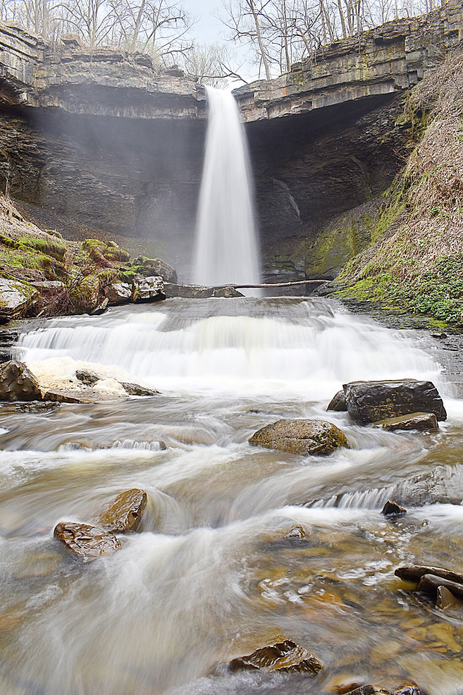
Description: Carpenter Falls is a really nice plunge falls that gets more interesting the more you explore. A few years ago a nice boardwalk was built here that made viewing the falls very easy. This will only take you to the top (it's a classic view though), and access to the base is more of an adventure, though not incredibly difficult. Also of note is that there is another falls downstream that is similarly, if not more scenic than this one, but it is currenty off-limits. There are plans to build a trail down here eventually, and you can bet I'll make a point of hiking it.
Hiking Description: Start in a small lot here: (42.813582, -76.340987). Head out on the wide boardwalk which follows near the road. Walk for just a few minutes and you'll come out to a lovely view of the falls from above (top picture, high water). If you're here in higher water, this is your best bet, because trying to claw your way around the hillside is not worth the trouble (believe me, I've tried), and mist will be a problem from creek level. If the water levels are lower though, there is some fun to be had down in the glen. You probably saw a long wooden staircase headed down just before the overlook deck. Take these to their end, and you'll nearly be to creek level. A prominent footpath continues upstream from the end of the staircase, but don't take it as it takes you nowhere interesting. Instead, backtrack and head downstream on a series of bootpaths. This is the easiest way to enter the creek as low bluffs get in the way up closer to the falls. From here, you can splash your way back upstream to the falls. You will first come to a small cascade (pictured in the foreground of the bottom picture). You can make some great compositions here, and this is pretty easy to get to. If you want to get to the very base, you should cross the creek below the cascade and climb up it from that side. It's pretty slippery, so be careful. From here, it's just a little bit further to the plunge basin. I'm not sure how stable this area is, so take care, but it certainly is magical.
Total Mileage: ~0.3 total
Difficulty: 1/10 (Very Easy) to the top, 7/10 (Moderately Difficult) to reach the plunge pool
Date First Visited: April 1, 2026
Date Last Visited: April 16, 2026
Rank: A+

View from the overlook, high water
_1_JPG.jpg)
View from creek level, average flow


Bucktail Falls 21'
NEW!
Description: Bucktail Falls is a small, but scenic and fun roadside waterfall found way out in the scenic New York countryside. The drive to get here is part of the fun, as you're winding through pastures and small woodlands for miles and miles, when suddenly, there it is! Be sure to come after rain for the best experience, as this is a small stream.
Hiking Description: There is just barely enough room to park here: (42.822525, -76.241058). You can see the falls clearly from here. The photo was taken from the other side of the creek though, which is a little tricky to get to without getting your feet wet.
Total Mileage: N/A
Difficulty: 0/10 (Roadside)
Date First Visited: April 1, 2026
Date Last Visited: April 1, 2026
Rank: A

Central NY
The Central New York Region is a very nice area that is most similar to the Finger Lakes as far as geography, but there are no more lakes. Instead, you are met with rolling hills and deep valleys with small towns. This part of the state is very rural, and many of these falls are far from the tourist path, but still certainly worth the trouble. The Central NY region is bordered by the Finger Lakes to the west, the Adirondacks to the north, and the Catskills to the east.
Tinker Falls ~50'
NEW!
Description: Tinker Falls can be one of two things: a pleasant outing to a tall, but weakly flowing waterfall, or if you can time it right, it can be a wild display of power and wonder. I was here roughly 24 hours after heavy rains moved through the area. The falls was flowing heavier than usual, but if I could have been here right as the rain ended, the scene would have been very different. One day...
Hiking Description: Park in a large and well signed lot here: (42.780204, -76.036278). Cross the highway (careful!) and pick up the wide gravel trail heading upstream along the unnamed stream. It is a flat 5 minute walk to the falls. The main trail will end a few hundred feet downstream of the falls (still a good view), but if you cross the creek and head upstream, you'll find that the trail actually continues! Many rock stairs are built into the hill, and you can get higher to perfect views, and even further to go behind the falls. It really is a terrific view from back there, even if it is flowing weakly.
Total Mileage: 0.6 total
Difficulty: 1/10 (Very Easy) to the base, 6/10 (Moderate) to get behind the falls
Date First Visited: April 1, 2026
Date Last Visited: April 1, 2026
Rank: A

Delphi Falls 65'
NEW!
Description: Delphi Falls is a large and easy to access waterfall in a newly established county park. As if this giant wasn't enough, there is an upper drop that is also quite scenic, but trails have yet to be established to get there. I will update with pictures once access is permitted.
Hiking Description: Park here: (42.866877, -75.901604). Walk on the wide paved trail headed upstream, quickly crossing East Branch Limestone Creek on a large footbridge. Keep going, and you'll come to the base of the falls in just a few minutes. There are some other trails you can walk through the park, but you can see no other waterfalls from them currently.
Total Mileage: 0.3 total
Difficulty: 1/10 (Very Easy)
Date First Visited: April 16, 2026
Date Last Visited: April 16, 2026
Rank: A


Chittenango Falls 130'
NEW!
Description: Chittenango Falls is once of the Empire State's most iconic waterfalls, and that is for good reason. Chittenango Creek drops 130 feet in two steep cascades forming a massive staircase. In the foreground are lush ferns and raging whitewater. The Gorge Trail offers a beautiful short loop in which you can view the falls from multiple angles, though none will compare with the view from the base. As if it couldn't get any better, Chittenango Creek almost never runs dry, so this giant should be flowing almost always!
Hiking Description: Park in the well signed lot for 'Chittenango Falls Park'. The trail starts in the northwest corner of the lot, heading down a few stairs and over to a view of the brink of the falls. Keep left, following signs for the 'Gorge Trail'. It will begin heading down quite a few stairs, coming to a decent view of the falls part way down. After more stairs, you will finally bottom out at creek level. A short spur trail heads left to a seasonal waterfall (quite scenic in high water), but if you keep right, it's just a few more steps to the large bridge over the creek. Look to your right and be amazed! You're a good distance downstream of the falls, but it really doesn't make it any less mesmerizing. The best views are from the far side of the bridge. Please make sure to take advantage of the foregrounds here, as they are some of the best I've ever seen. The creek cascades endlessly while lush moss dots rocks in the creek. Whenever you finally decide to leave, you can return the way you came, or continue the loop of the Gorge Trail. It's a bit more rugged on the other side, but it's really scenic too, so you decide.
Total Mileage: 0.55 loop
Difficulty: 5/10 (Moderate)
Date First Visited: April 16, 2026
Date Last Visited: April 17, 2026
Rank: A+
Stockbridge Falls 41'
NEW!
Description: Stockbridge Falls is a surprisingly scenic roadside cascade found in the endless hills. It is actually a series of small drops that come together to form a great composition. My first visit here was after heavy rain, and it was so flooded that it lost all its character. My second visit however, made me glad I came back. It's a delightful scene, and what you see pictured is taken directly from the road! Some people will head upstream to get closer to the many small drops, but I saw no need to as the view from the roadside was so good. This is a great companion waterfall to nearby Chittenango Falls.
Hiking Description: N/A
Total Mileage: N/A
Difficulty: 0/10 (Roadside)
Date First Visited: April 1, 2026
Date Last Visited: April 17, 2026
Rank: A

Rexford Falls 35'
NEW!
Description: Rexford Falls just might be the most out of the way waterfall in all of New York, excluding the Adirondacks. It is far from any other falls, far from any major town, far from anything at all, really. The drive out to Sherburne is a pleasant one though, and this is a fun falls to visit. Access to the top is super easy, and getting to the bottom...is not. More info below!
Hiking Description: Park in a small roadside park here: (42.679364, -75.471302). Just 100 feet to the south of here is an old metal bridge crossing Mad Brook. Head through the turnstile and peer down on your right. You are above the falls, up high! The falls may be just 35 feet high, but it's a lot farther than that to the base of the falls. You can't get a good view from up here at all, so if you want to get to the bottom, this is how you do it: continue across the bridge to the south side, and take a right. So now you're headed west, following Mad Brook downstream, but you're still high above it. There isn't much of a path, but the woods are open, so it's easy going. You'll be following a fence that blocks you from the high drop into the glen. You'll cross a clearcut area and then re-enter the forest. This is around the point where the fence finally ends. You'll also start going downhill, steeply! It's really not that bad if you take it easy, though. You don't want to start heading towards the creek just yet, but just downhill and downstream. Navigate to these coordinates: (42.678666, -75.474193). At this point, hit a 180 to your right, and head down towards the creek. If you've done this right, you should see a ladder to help you down what has become a short bluff. Even if you can't find the ladder (or if it's gone), you can probably enter the creek a little ways downstream of here. In any case, this is where things are about to get real. There is no trail up to the falls, and you will have to creek walk. It's not very far, but it's not very easy either. The easiest way up is to cross the creek not far from the ladder, and stick to the north side all the way up to the base. There are still some tricky spots (I actually fell and got soaked as a matter of fact), so be careful. It's a really good view from the base though, and not a lot of people dare to go here, especially when the falls is flowing full like it was for us.
Total Mileage: ~0.5 total
Difficulty: 7/10 (Moderately Difficult)
Date First Visited: April 1, 2026
Date Last Visited: April 1, 2026
Rank: A+

Catskills
The Catskill Mountains are a pocket of rugged mountains found in southeastern New York that hold some really terrific waterfalls. This is the closest range to New York City, so expect some fellow visitors, but if you come after rain or in the spring, it will be worth it. The tallest waterfall in New York resides here: Kaaterskill Falls, and it is a spectacle to say the least. Many other great falls here as well, and many more to come! The Catskills are bordered by the Central NY Region to the west and the Capital Region to the north.
Kaaterskill Falls and Bastion Falls (2) 231'/62'
Description: Kaaterskill Falls is the tallest waterfall in New York and it will surely leave an impression. It first falls in a towering horsetail before dropping again in a steep cascade. It's possible to view both drops up close, and in tandem, which is quite awe-inspiring. The height is often listed as closer to 260 feet, but I've come to trust the lidar data from the Waterfall Survey, which sites 231'. There used to be two ways to get to the falls, with the more popular route being to park on NY-23A, but they closed this parking area due to what was surely safety concerns, as you would have to walk in the shoulder of the busy highway. The other way is now the main route, and it's to start from Laurel House Road. This starts you at the top of the mountain and leads all the way down to the base of Kaaterskill and on to Bastion, descending 700 vertical feet along the way. It's pretty tiring on the way out, but if you come when the falls is flowing, it will surely be worth the trouble. I got to visit when the fall foliage was peaking, and it was a sight to behold.
Hiking Description: Park in the large lot at the end of Laurel House Road here: (42.195759, -74.063540). Pick up the wide gravel trail headed south. If the water is up, you may be able to hear the falls already. It will wind gently downhill, and at 0.15 miles, you will come to a signed split. Take a right on the short spur trail to the overlook of Kaaterskill Falls from above. The trail ends at a wooden deck overlooking the upper drop and the wilderness beyond at 0.3. It's pretty amazing. You may also be able to see a long staircase far below you descending to the base of the falls. We'll be there soon! From here, retrace your steps to the split. Take a right now, away from the parking lot. Very quickly, you will come to a bridge over Spruce Creek, a few hundred feet upstream of the falls. Once across the bridge, there will be another split. Stay right here, and climb up a few stairs. Up the hill, the trail flattens for a bit, before coming to another junction at 0.6 (counting the split to the upper overlook). Take a right here, following signs for the base of the falls. You will start going downhill here, and it's a long way down to the base, let me tell you. After a ton of stairs, the falls will come into view through the trees, as you get your first glimpse of the lower drop. Before you get to the true base, pick up a short spur trail that leads to the base of the upper drop. It leads right on over to the creek where the ~160 foot upper drop crashes into the rocks. There's a ton of mist, but it's worth a look, and I doubt you'll forget it. I got completely soaked from the mist here, but it was worth it. From here, retrace your steps to the seemingly never-ending staircase to the very bottom. Keep on going down, and by 1.0, you'll be greeted with the postcard shot: the lower drop with the upper drop in the background, framed by towering cliffs and beautiful foliage. It really is one of the East Coast's greatest views, and I was looking right at it! I lingered here for quite a while, and I wouldn't blame you for doing the same, but if you can pull yourself to leave, there's still one more treat in store if you're up for it. The trail keeps going downstream and downhill, following Spruce Creek. It gets pretty rooty and rocky, but it's not too steep anymore. The scenery is first rate, and most of the visitors won't venture down this far. About 15 minutes from the base of Kaaterskill, you'll come to the top of Bastion Falls, which falls in two distinct drops similar to its upstream sibling. Go down one more long set of stairs and you'll be at the base of Bastion Falls, where the trail ends at NY 23A, 1.35 miles from the start. The best view is from up on the highway bridge over the creek (pictured), which you can safely access from the side of the gaurdrail opposite of traffic. You're pretty close to the old trailhead now, but it's off-limits to park anywhere on the highway as of 2025. That means that once you're finished at Bastion Falls, you're gonna have to climb all the way back up to Laurel House Road. Stay a while, and pace yourself on the way back up, stopping to see Kaaterskill again on the way. It's worth the effort, I swear!
Total Mileage: 0.6 total to upper overlook of Kaaterskill Falls, 2.0 total to base of Kaaterskill Falls, 2.6 total to see Kaaterskill and Bastion Falls
Difficulty: 3/10 (Easy) to the upper overlook, 7/10 (Moderately Difficult) to the base of Kaaterskill and Bastion Falls
Date First Visited: October 14, 2025
Date Last Visited: October 14, 2025
Rank: A+

From top to bottom, left to right:
Kaaterskill Falls from Upper Overlook
Katterskill Falls Upper Drop
Kaaterskill Falls Both Drops
Bastion Falls Both Drops
Map & Key


Plattekill Falls 51'
Description: Plattekill Falls is a really nice plunge waterfall found down a short trail. The trail is a bit steep, but it won't take long, and the view from trail's end is fantastic. Along the way, you'll pass a beautiful view of Platte Clove, which adds to the already scenic experience.
Hiking Description: Park along the south side of Platte Clove Road here: (42.133432, -74.086006). The trail heads away from the road and comes to a split within 100 feet of the road. The trail to the right leads to a nice bridge over Plattekill Creek, and the trail to the left leads to the base of Plattekill Falls. Head left here, going downhill slightly. After 0.1 miles, you will come to a really great view of the wilderness and Platte Clove. From here, the trail turns hard right and steepens considerably, reaching the base of the falls after just 0.2 miles from the road. The falls explode off the precipice with a lot of power, shooting far away from the cliff, before crashing into the creek below. It's quite the sight.
Total Mileage: 0.4 total
Difficulty: 5/10 (Moderate)
Date First Visited: October 14, 2025
Date Last Visited: October 14, 2025
Rank: A+
Plattekill Falls


Platte Clove
Adirondack Front Range
You're geting near the end now! This next region, which I will refer to as the 'Adirondack Front Range', is the land set between the eastern shore of Lake Ontario and the encroaching Adirondack Mountains. This area is sparsely populated, with only small towns set in the hills. There are some nice waterfalls here, but they are not nearly as plentiful as in other regions of the state. The good news is you could pair some of these falls with a trip to one of the beautiful beaches on Lake Ontario, as they look to be some of the best in all of the Great Lakes! This area is bordered by Lake Ontario to the west, Canada to the north, the Adirondacks to the east, and the Central New York region to the south, with Syracuse, Rome, and Watertown serving as boundaries to the extent of the region.
Salmon River Falls 111'
NEW!
Description: Salmon River Falls is a towering affair that is one of New York's greatest waterfalls. Too bad the water is almost always diverted! What would naturally be a 250 foot wide breadth is hardly ever achieved due to hydroelectric activity. The good news is that even in this diminished state, the falls is still quite scenic, warranting a visit. Better yet, it's still possible to see the falls reach their full potential during peak snowmelt, and perhaps even after prolonged rain events. The trail to the upper viewing area is short and easy, and the Gorge Trail will take you all the way to the base. This route will be closed for much of the year however, and if the falls is flowing with any power, spray will be a nightmare. More info below:
Hiking Description: Park here: (43.548926, -75.943562). Head east on a wide gravel trail, following the sound of falling water. Within just a minute or two of walking, you'll come to a fair view of the falls. There is some brush in the way, but you can still get a sense of scale. If you want to head to the base, keep going a bit further to a trail split. The trail going left/straight heads to the brink of the falls, while the trail to the right leads to the base of the falls on the Gorge Trail. Take this trail, quickly passing a gate (this gate was shut, but unlocked on my visit). Past the gate, you will start going downhill steeply on a bunch of stairs before it opens up considerably, and you begin down a barren hillside with picture-perfect views of the falls. This is where the first photo provided was taken. From here, the trail will switchback twice and then bottom out at river level. Spray will be an issue down here, even in lower water, so don't bother bringing any camera equipment this far. I continued with my waterproof camera, however. If you keep going throught the relentless mist, you can get up all the way to the very base. Yes, you can reach out and touch this giant if you dare! It's quite a scary scene getting so close, but it's also one I won't soon forget. The second photo was taken from the base, in between waves of drenching mist. I got completely soaked; like, just got out of the pool soaked, but it was a lot of fun.
Total Mileage: ~0.4 total
Difficulty: 1/10 (Very Easy) to the upper overlook, 6/10 (Moderate) to the base
Date First Visited: April 14, 2026
Date Last Visited: April 14, 2026
Rank: A+


Totman Gulf ~45'
NEW!
Description: Here is a scenic little waterfall that not many people have been to. It's right next to the road, with a short, somewhat steep trail leading down to the base. It occurs where an unnamed tributary dumps into the larger Fox Creek, within Totman Gulf. The textures found on the bluff wall where the water falls are very appealing. Visit after rain for the best experience (I was here after an inch of rain in April).
Hiking Description: Park on the north side of the road here: (43.763545, -76.000958). There is room for maybe two cars. The last half mile is a very bumpy gravel road, but it is flat, so most cars should be able to make it if you go slow. From here, pick up the wide dirt trail heading downhill. It will switchback once, and then let you out at creek level in no time. The falls is on the opposite side of Fox Creek, but it's a terrific view from here anyway. Looks like a fun place to wade as well!
Total Mileage: ~0.25 total
Difficulty: 4/10 (Moderately Easy)
Date First Visited: April 14, 2026
Date Last Visited: April 14, 2026
Rank: A

Talcott Falls ~40'
NEW!
Description: Talcott Falls is a beautiful roadside waterfall found right next to Highway 11. The land surrounding the falls is heavily posted, and I'll admit that I did trespass by a few feet so I could get a shot without branches in the way. You can decide what you want to do.
Hiking Description: N/A
Total Mileage: N/A
Difficulty: 0/10 (Roadside)
Date First Visited: April 14, 2026
Date Last Visited: April 14, 2026
Rank: A

Whitaker Park (2+) ~40'
Description: Whitaker Park is a wild park that serves as a campground and day use area. The season only runs through the late spring to early fall, and seems to vary wildly based on the year. When I visited in 2024, it was closing on October 15, but the sign said it would close September 16 in 2025, so who knows. The good news is that this falls flows year round, and you'll actually want to visit in lower water for the best experience. You'll have to follow the creek to the falls, and it won't be possible in high water. The trail to the falls is fascinating, and you'll see why in the hiking description:
Hiking Description: Park near the sign that says "Waterfalls -->" in Whitaker Park in Lowville. You can't miss it when you drive in on the main road. From here, head down a steep hill on a wide path that quickly leads to the river and a nice viewing deck and staircase to creek level. The only issue is that part of the staircase was busted off, rendering the whole thing useless. I found a way down by walking under the deck, which was rough, but short. You aren't at the falls yet, just the river. Turn left, following Roaring Brook downstream. The creek is very pretty and flat here. Follow the river for about five minutes, and you'll arrive near the top of the falls at 0.2 miles from the parking lot. This is where things get tricky. There is very little space to maneuver here, but you can pick your way downstream if you go slow. This tight spot is only a few feet, so it shouldn't be too bad. If the weather is warm, it may be easier to just enter the creek briefly. Once through this spot, you're at the top of the trio of falls, but you can't see much falling water from here. However, you may see your route to the base, and it's gonna take some work. Basically, on your left of the falls, there is a massive expanse of glacially carved rock that you can walk/climb down like stairs all the way to the base of the upper falls, and beyond to the base of the middle falls. There is no way to get to the bottom of the lower falls, but it is the least interesting of the three anyway. I would recommend just coming here in the summer, so the flow will be perfect, and it will be warm enough to wade in the scenic creek. I will include a picture of what I have began calling "The Whitaker Climb", which is the large rocky area you can climb down to see the upper and middle falls from up close. I'm standing part of the way up.
Total Mileage: ~0.5 total
Difficulty: 8/10 (Difficult)
Date First Visited: October 13, 2024
Date Last Visited: October 13, 2024
Rank: A+

Upper Falls

Middle Falls

Me ascending the 'Whitaker Climb', with Middle Falls visible
Talcottville Falls ~20'
NEW!
Description: Also known as Sugar River Falls, Talcottville Falls is a wide shelf fall which is significantly off the radar, despite being right next to a state highway. There are no signs to point you here, so perhaps that is why. It's easy to get here though, and this fall will be flowing throughout most of the year.
Hiking Description: There is a driveway leaving NY-12D here: (43.535708, -75.366004). It looks private, but rest assured: this land is open to the public. It's really easy to miss this driveway, but this is your route down. I drove down this road, but it's in really bad condition, and a low vehicle could get stuck, so you might want to park on the shoulder of the highway, as ackward as that is. The driveway goes down a short hill, then turns hard left and leads over to the base of the falls, just a few hundred feet from the highway. It is impossible to see the entire falls from dry land due to an impeading bluff on the left, but you can see most of it.
Total Mileage: Minimal
Difficulty: 0/10 (Roadside) or a very short walk
Date First Visited: April 14, 2026
Date Last Visited: April 14, 2026
Rank: A

Pixley Falls 30'
NEW!
Description: Found in the quaint Pixley Falls State Park is a really nice 30 foot drop that is easy to get to. I was here during typical springtime conditions, but the appearance of the falls can change quite a lot depending on the season and flow, so hopefully I will return here someday.
Hiking Description: Pass by the large lot and park down here: (43.401909, -75.342845). Now head out on the obvious trail, which is well marked. Head down a short hill, quickly taking a right to continue down to the falls (the left trail heads downstream following the creek). You'll come to the base of the falls shortly. A small tributary enters from the right, and a neat waterfall exists here during higher water. Many compositions can be made of Pixley Falls, as you can get up close or head downstream and work some nice creek foregrounds. My favorite view was just a classic landscape, though.
Total Mileage: ~0.2 total
Difficulty: 3/10 (Easy)
Date First Visited: April 14, 2026
Date Last Visited: April 14, 2026
Rank: A

Remsen Falls 12'
NEW!
Description: Remsen Falls is a small, but interesting waterfall that is easy to get to. It is unfortunately cluttered by manmade obstructions, and is likely only worth a visit if you're a real enthusiast.
Hiking Description: Park here: (43.323404, -75.186034). Walk across a neat footbridge over Cincinatti Creek, and then head left over the lawn to a nice deck overlooking the falls.
Total Mileage: 0.1 total
Difficulty: 1/10 (Very Easy)
Date First Visited: April 14, 2026
Date Last Visited: April 14, 2026
Rank: B+

Adirondacks
The final region is the Adirondacks, which is a sprawling area that encompasses most of northern New York, save for the eastern shore of Lake Ontario. Despite often being labled as a massive park, it is more of a large collective of public and private attractions, with towns and settlements interspersed within. Either way, there are some massive waterfalls here, most of which I haven't gotten to yet. The falls up here look quite a bit different than the falls in southern New York, and many are much wilder, but that's part of the appeal. Enjoy the solitude of this remote area! The Adirondacks are bordered by the Adirondack Front Range to the west, Canada to the north, Vermont to the east, the Capitol region to the southeast, and the Central New York region to the southwest.
Grass River Waterfalls (4+) 10'-30'
Description: There are many waterfalls on the poweful and wild Grass River, and I visited the most popular four. From west to east they are Basford, Sinclair, Twin, and Rainbow Falls'. The only other publicly accessible waterfall that I know of is Copper Rock Falls, which I did not visit. Each of the four have short and mostly easy hikes to get to them, with four different parking areas. I recommend visiting from west to east, as the falls just get better as you go.
Basford Falls:
Park roadside here: (44.342958, -75.053279). There is room for a few cars on the south side of the road here, near the trailhead sign. Walk under the wooden sign, which says 0.3 miles to the falls. The trail is wide and easy to follow, going up and down some hills, rolling with the land. Near the end, you'll begin to hear the falls, and the trail steepens considerably to reach river level. This is the most difficult part of any of the hikes on the Grass River, and still it's not too bad. Once at the bottom of the hill, the trail fades, but the woods is very open here, covered with pine needles. It's very pretty. The falls is rather small, but the setting is very nice, so visit if you wish.
Total Mileage: 0.6 total
Difficulty: 4/10 (Moderately Easy)
Sinclair Falls:
Of the four falls here, this one has the shortest hike, and it's almost roadside. Park in a small lot here: (44.337760, -75.045437). Another wooden sign points towards Sinclair Falls, heading into the woods going north. It will lead quickly to the falls, and wrap around to some more views. It won't take more than two minutes to get there.
Total Mileage: 0.1 total
Difficulty: 2/10 (Easy)
Twin Falls:
Twin Falls is a large waterfall that cannot be fully appriciated because the viewpoint is from so far away. Still worth seeing though. Park in a large dirt pullout here: (44.334268, -75.026306). Follow an old road down to a gate, heading towards the river. Pass around the gate, and the trail will narrow. It gets very thin through some weeds, but after just a minute or two it will let you out at the river's edge. The first thing you'll notice is that it's hundreds of feet wide, and the waterfall is way, way on the other side of a massive pool. You're not going to be getting any closer though, so just use a long lens. It's called Twin Falls because a small portion of the river splits and is falling to the left of the main drop. You're much closer to this small falls, but it's not easy to get up near to it either. It's not worth the time anyway.
Total Mileage: 0.1 total
Difficulty: 2/10 (Easy)
Rainbow Falls:
The largest and most impressive of the Grass River Waterfalls, Rainbow Falls is a must-see. It will be flooded through much of the year, and actually looks best in dry weather. I visited in October after a dry summer and fall, and it was still running powerfully. The trail is short and scenic, and begins here: (44.307334, -74.994158). After parking on the west side of the road, pick up the easy trail headed west into a beautiful forest. After about a quarter mile, the terrain will get much rockier, but the trail remains easy. You'll come to a small footbridge over a small portion of the Grass River that has branched off. On the other side, you're technically on an island now, and the falls is just ahead. The trail will split into many bootpaths, and it's really just easiest to explore them all. You'll end up at some fantastic viewpoints above the river of the falls, some of which will be getting sprayed with heavy mist. If you move a bit further downstream, it'll get dryer. After the trail splits, it gets a bit slick, but it's not too bad if you go slow. It's a bit tricky to get a good photo of Rainbow Falls due to the heavy mist and minimal places to view the falls, but it really is something to experience.
Total Mileage: 0.6 total
Difficulty: 3/10 (Easy)
Date First Visited: October 13, 2024
Date Last Visited: October 13, 2024
Rank: A+

Basford Falls
Sinclair Falls

Twin Falls

Rainbow Falls
