Waterfalls in South Carolina
4
While there aren't nearly as many waterfalls here as in North Carolina, there are still some real great ones here, many of which I haven't visited yet. All the waterfalls in South Carolina are in the northwest corner, near the borders with Georgia and North Carolina. Also, most of these falls occur in Sumter National Forest, with a few exceptions.

Sumter National Forest
Reedy Branch Falls ~30'
Description: Reedy Branch Falls is a small and low flow falls that wouldn't be worth the time if it wasn't for its easy access and proximity to other bigger waterfalls. Visit if you're so inclined.
Hiking Description: Park in a large, but unmarked gravel lot here (34.807431, -83.281029). A wide gravel trail starts behind a gate, heading downhill for a short distance. After just 0.1 miles, you'll come to a small footbridge over a small stream. The trail continues upstream through a sandy area and to the falls just beyond, around 0.15 miles from the road.
Total Mileage: 0.3 total
Difficulty: 2/10 (Easy)
Date First Visited: February 19, 2025
Date Last Visited: February 19, 2025
Rank: B-

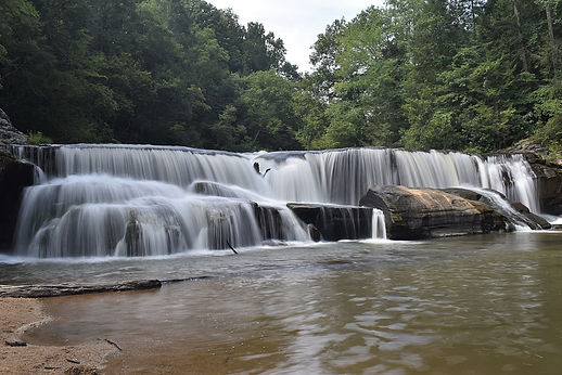
Opossum Creek Falls ~50'+
Description: Opossum Creek Falls is a tall and wild waterfall found at the end of a long and rather exhausting hike. You pass a beautiful beach on the banks of the Chattooga River on the way though, which makes it worth the effort. The trail is scenic, and you're close to other falls, so plan a visit.
Hiking Description: Park on the side of the gravel road here (34.773378, -83.304142). The trail starts on the south (left) side of the road, and it doesn't waste any time in starting the descent, winding through some switchbacks. Just 0.2 miles in, you may notice that you're crossing a very small stream. It's so small that you may not even notice it, but this is the beginning of Camp Branch, which you will more or less follow all the way down to the Chattooga River. Continue on the trail, which flattens out and crosses Camp Branch two more times, which should be an easy rock hop unless water levels are unusually high. The walking is easy for a while, but eventually you will have to climb under or over multiple downed trees. Some of these areas are tricky as the trees are huge. By 1.0 miles in, you should see Camp Branch Falls down on your left. This is a small falls, and there is no way to get down there without a dangerous off-trail scramble, so I'd skip it. After you pass the small falls, things get real, as the trail is nothing but downhill for the remainder of the way to the Chattooga River, which you finally meet at 2.0. At the river, there is a beautiful beach that is certainly worthy of a stop. Opossum Creek empties into the Chattooga River here, and it really is a spectacular spot. It might even be more scenic than the falls still to come! We splashed around here for a while, and this really is a pristine area, so enjoy. To get to the falls from the beach, the trail wraps around and starts back inland, following Opossum Creek. The trail is flat here (a welcome change), but there's still one more obstacle. At 2.2, you'll reach a significant creek crossing. This is Camp Branch, just before it empties into Opossum Creek. It's much larger here compared to the puddly area you crossed near the beginning, and it'll be tricky to stay dry here. Take a minute to appriciate that you've walked so far that you've come from headwaters to mouth of this stream. Opossum Creek Falls is not far by this point, so continue on, through a rocky area, and reaching the tall, cascading falls at 2.3 miles from the road. Linger for a while, beacause it's an 800 foot climb back to the car!
Total Mileage: 4.6 total
Difficulty: 7/10 (Moderately Difficult)
Date First Visited: February 19, 2025
Date Last Visited: February 19, 2025
Rank: A

Long Creek Falls ~30'
Description: Long Creek Falls is a very scenic twin waterfall that has good flow year-round. I really enjoyed this falls, and the hike is easy, until you get to the end, where the trail descend 200 vertical feet in a tenth of a mile. It's very steep, and you'll be panting on the way out, but it's doable because there are roots and trees to hold on to on the way down. Once you get to the base, you're at the spot where Long Creek empties into the Chattooga River (not unlike how Opossum Creek ends). You can see the falls clearly from here, and it's a great view. However, the falls are still about 100 feet upstream. If you wade across the stream from where the trail ends, you can make your way up the other side of the stream to near the base of the falls and WOW! It is awesome, so I would highly recommend doing this. If you made it down that descent, the wade should be a piece of cake in comparison.
Hiking Description: Park at the end of Turkey Ridge Road here (34.777586, -83.312276). This is just about a mile further down the road from the Opossum Creek Falls Trailhead. On the north side of the road is the trail, which is an old road. Begin down the trail, going downhill, and come to a split at 0.12 miles. The left trail leads to an overlook high above the Chattooga River, and the right trail is the trail that leads to the falls. Continuing on, cross over a large fallen tree, and the the old road flattens out. At 0.4, there is an area where there are a bunch of fallen trees blocking the road, and a bootpath heads to the right and around it, before leading back to the road. By 0.65, the old roadbed ends (many decades ago, this was likely the trailhead, but this road is not passable to vehicles anymore). The trail narrows and you'll pass a confusing and unsigned split. Keep right, and you'll know you went the right way when you pass a signboard with information about the Chattooga River (coordinates: 34.7833663, -83.3157397). The walking stays easy, and at 0.8 miles the trail bears right. You may not notice it, but a faint side trail heads left downhill to a small waterfall known as Homer's Falls. This fall is small and not worth the effort of the difficult side trail. Back on the main trail, you are now paralleling the Chattooga River, but you'll notice it is far, far below on your left. Keep going, and the trail stays flat until 1.45, when it veers left and starts going steeply downhill. Take your time, as the trail goes down and down and down! You'll be wondering if you'll ever reach the bottom, but when you do, you'll be glad you came. The view from here is lovely, but it is possible to get even closer to the falls. Cross the creek (it's shallow and sandy), and then there is flatland on the other side. Walk upstream, climb over some rocks, and you'll be near the base of this beautiful falls. I've attached a photo from the trails end, and from near the base, so you can decide what you want to do.
Total Mileage: 3.1 total
Difficulty: 8/10 (Difficult)
Date First Visited: February 19, 2025
Date Last Visited: February 19, 2025
Rank: A+
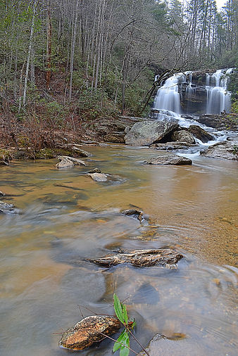_3_JPG.jpg)
View from trail's end (left); view from near the base (right)
_4_JPG.jpg)
Riley Moore Falls 12'
Description: Riley Moore Falls is a nice waterfall that is found at the end of a rather boring hike, and looks to be a great swimming hole. It's not the biggest waterfall, but the wading is great, so it might be worth a visit in warm weather. However, my time at the falls was cut short because I was getting swarmed by sweat bees while trying to wade. It was also pushing 90 degrees when I was here, and I was sweating to say the least. Maybe go in the springtime, and not August.
Hiking Description: You'll park roadside here (34.739570, -83.189857). This is a few miles down a bumpy gravel road, so drive slow. From this point, there is an even rougher road that branches off to the right, and you'll want to either start walking down this road, or start driving down it if you have a 4x4 and want to risk it. It's pretty bad. After 0.5 miles, keep left to start the trail proper. If you're driving, you won't be getting any farther. It's another 0.5 miles to the falls from here. Note that while this hike is pretty easy, the whole way there is downhill, so the whole way back is uphill, and if it's really hot like it was when I was there, this will be daunting.
Total Mileage: 2.0 total
Difficulty: 5/10 (Moderate)
Date First Visited: August 2, 2021
Date Last Visited: August 2, 2021
Rank: A