Waterfalls in Pennsylvania
24
Pennsylvania might just be the be the best state ever for waterfalls! There are so many waterfalls in this lovely state, found all over the place. Some are found on nice, easy trails, and others are found in the deep wilderness. There's a little bit for everybody here, so plan a visit. Two of the greatest waterfall hikes in the whole US are here: Bushkill Falls, which is regionally famous for its large falls and intricate set of boardwalks, and Ricketts Glen, where you can see 22 falls on one trail. I recently got back and explored the Poconos for the first time, and saw a ton of new waterfalls! I plan to get back here, perhaps multiple times in 2026, so stay tuned.
Northwest Pennsylvania
Northwestern PA is not the most scenic part of the state as seen from the highway, but there's lots of neat areas if you know where to look. I actually still have a good number of falls to visit here, but the two I've seen so far were scenic and easy to get to.
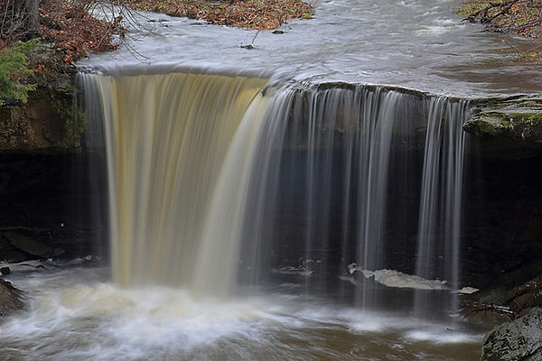
Big Run Falls ~20'
Description: Big Run Falls is a nice waterfall in a quaint city park. Easy access to the top (where the photo was taken from).
Hiking Description: Park here: (40.977009, -80.318610). Walk on the road for a short distance headed west. You will pass by the top of the falls after 200 feet, but the best view (pictured below) will be found after 500 feet.
Total Mileage: 0.2 total
Difficulty: 1/10 (Very Easy)
Date First Visited: December 11, 2021
Date Last Visited: December 11, 2021
Rank: A-
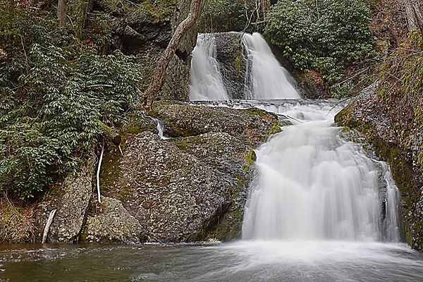
Homewood Falls ~30'
Description: I really liked Homewood Falls since you can walk behind it, and the hike is simple, but scenic. It's not massive by any means, but it has character, and I think it's a great place to visit, especially after rain. Note that it is also called Buttermilk Falls.
Hiking Description: There is a bit of room to park here: (40.813144, -80.325837), which is the closest spot to the trailhead. If that's full, head up the road and park here: (40.814599, -80.326766). From the first mentioned parking lot, head west on the dirt trail which quickly starts heading up the gorge of Clarks Run. The run is far below you here, but as you continue down the trail, which is mostly flat, the creek will get nearer to your level. Soon, you will go down some stairs and get beneath a small bluffline. The trail gets rockier here, but the falls is within sight. If you continue on (turns to boulder scrambling by this point), you can get behind the waterfall and over to the other side of the creek. Very beautiful area.
Total Mileage: 0.2 total
Difficulty: 3/10 (Easy)
Date First Visited: December 11, 2021
Date Last Visited: December 11, 2021
Rank: A+


Laurel Highlands
The Larel Highlands is a broadly defined region of southwestern PA that includes some real nice waterfalls. Ohiopyle State Park is part of the Laurel Highlands, but because there are so many waterfalls in and arund the park, I've decided to give it a region of its own.
Buttermilk Falls 45'

Description: Buttermilk Falls is a very nice waterfall that has been turned into a wonderful park just a few years ago back in 2017. The trail to the top of the falls is easy and paved, and a well-constructed boardwalk leads to the base and behind the falls. There is some interesting history here too.
Hiking Description: Start in the parking area at the end of the road here (40.418989, -79.067862). The trail heads south from here, passing a clearing, and then entering the woods. The walking is uninteresting for a few minutes, but then the trail will wrap around to the left and begin heading on a gentle downhill. You can tell that the land to your right goes down quite some distance. At about 0.2 miles, you will come to an overlook of the falls from above. It is somewhat obscured, but you can see the trail that leads to the bottom from here. If you continue on, you'll go down some stairs, and cross a rather extravagent bridge over the small stream. After this, the trail winds down a solid 100 or so stairs to the bottom of the falls. Watch out because it gets pretty incredible down there. The trail continues halfway behind the falls and dead-ends, but it lets you get far enough around to fully enjoy the falls. If water levels are up, water will pour directly on to the trail, so you may want to bring an umbrella. The only problem with this place is that you can't get a view of the falls that doesn't include the fences along the trail, but I'd say it's worth it because this lets you get so close to the falls.
Total Mileage: 0.5 total
Difficulty: 3/10 (Easy)
Date First Visited: August 9, 2024
Date Last Visited: August 9, 2024
Rank: A
Buttermilk Falls during high water
Hinckston Road Falls ~60'
Description: The aptly named Hinckston Road Falls is found along Hinckston Road in Johnstown. The falls is not entirely natural, as it is the outflow of Hinckston Reservoir, but it really is something to see. The photo provided was taken from the side of the road - you can see this one without getting out of the car. Make sure you don't leave the road while you're here, because that is private property, and there was a cop patrolling the area. He was a real nice guy and I chatted with him for a while about the area, but it just shows you that they mean business about this property. Enjoy.
Hiking Description: Roll down the window and gaze.
Total Mileage: N/A
Difficulty: 0/10 (Roadside)
Date First Visited: August 9, 2024
Date Last Visited: August 9, 2024
Rank: A-

Hinckston Road Falls during high water
Ohiopyle State Park
Ohiopyle State Park hosts numerous waterfalls, all of which are close together, and you could probably visit all of them in one day and it would be a waterfall wonderland! So far, I've only been to two of the falls here, but there are more, and I'll get to them someday. This is one of Penna's finest parks, and certainly worthy of the popularity it recieves!
Cucumber Falls 30'
Description: Cucumber Falls is one of the more famous waterfalls in Ohiopyle Park, along with Ohiopyle Falls itself and Fallingwater, and for good reason. Cucumber Falls is one of the most picture perfect waterfalls in all of PA. We were here at somewhat low water, but it still looked fantastic, and we had a wonderful time exploring the area and wading the creek. I plan to return someday during higher water to see it in a different perspective, and also to visit the lesser known waterfalls in the park.
Hiking Description: Park in the well signed parking area here (39.862784, -79.502691). The trail starts on the north side of the lot, heading out on a wide trail. Very quickly, you will come to a split. To the left is a bridge over the creek, and to the right is the trail to the base of the falls. This will go down a few stairs, and lead to a decent view of the falls from above, then it will wind down to the bottom of the falls. To get the best views, you will have to do some boulder scrambling. I waded to the other side of the creek (right photo), and it's very pretty over there too. you can even get behind the falls with some effort.
Total Mileage: 0.2 total
Difficulty: 3/10 (Easy)
Date First Visited: August 9, 2024
Date Last Visited: August 9, 2024
Rank: A+


Ohiopyle Falls ~15'
Description: Ohiopyle Falls is a high volume waterfall found in it's namesake park that is an impressive sight. There are two ways to view it: a paved trail near the park visitor center, or a more rugged hike along the Ferncliff Peninsula. Both views are great, but the trail on the peninsula is sketchy in spots, so you decide.
Hiking Description: To get to the easy views, park here at the visitor center (39.868150, -79.494407). Just over to your west is a paved trail that quickly leads to a large wooden observation deck. This view is seen in the left photo. You can also get a view from the other side by hiking the trail around the Ferncliff Peninsula. Start this trail here (39.872033, -79.494185). The trail heads south, and is very easy and flat at first. You will go under a massive bridg; this is the Great Allegheny Passage, a popular rail trail. A short distance past the bridge, you will reach a trail split. You've been hiking on a short spur, and the trail you've just reached is the loop around the peninsula. Head left here. The trail stays flat and easy, and then you will approach the river. You get within a few feet of the river, and this is where the trail starts to get tricky. The trail will follow very close to the water's edge, and there is no real trail, you're just walking on the rocky riverbank. It's still flat, but these rocks can be slick, and the footing is uneven. The trail is blazed in yellow, and on these rocky sections, yellow paint is splotched on the rocky ground, which I thought was pretty interesting, and also really useful. Eventually, you will come to the brink of the falls. I wouldn't get to close to the edge of that if I were you, as there aren't any fences. From here, the trail enters the woods on a short, steep ascent, then flattens for just a bit, when you'll see a sign saying "Falls Overlook" pointing to the left. This spur goes down a few stairs, and you'll have your view (right photo).
Total Mileage: <0.1 total from visitor center, 0.6 total on Peninsula Trail
Difficulty: 1/10 (Very Easy) from visitor center, 5/10 (Moderate) from Peninsula Trail
Date First Visited: August 9, 2024
Date Last Visited: August 9, 2024
Rank: A-


Poconos
If you know you're geography, then you'll know that I just skipped from western PA all the way to the east side. There are a ton of waterfalls in central PA, including some of the states' best, but I haven't been to them yet. However, I recently got the chance to visit the Poconos, and WOW! It was a sight to see. Most of the falls here are located in the Deleware Water Gap National Recreation Area, and the park service has constructed very nice trails to these falls. The two exceptions are Bushkill Falls (which is privately owned) and Marshalls Falls (which is a city park). This would be a great place to visit if you're new to the waterfall game, because the trails are so wonderfully constructed, the falls are huge, and many of them have good flow into the summer months. For a real trip to remember, come in April when the snow is melting and the creeks are running high, as I did. I would also reccomend making the small town of Stroudsburg your base camp if you visit here. We stayed right in the downtown and it was a blast. This really is a terrific area, even if you're not into waterfalls. Entries are listed from south to north, generally following Route 209.
Marshalls Falls ~20'
Description: Marshalls Falls is a scenic and wild-looking falls that is really easy to get to. The falls drop into a small gorge, and the rock walls come in and nearly hide the falls from view. With some careful footing, you can find a spot where you can see most of the falls from between the bluffs. The park as it exists today has only been open since 2023. A short paved trail and boardwalk was constrcuted, which replaced the old scramble path to get there. Hooray!
Hiking Description: Park at the new parking lot here (41.051188, -75.137364). The trail heads out on a paved trail, winding slowly downhill, before coming to a boardwalk. This continues down to the creek, which is crossed on a large bridge. You can see the falls on your left, and if you continue on past the bridge, you can get even closer.
Total Mileage: 0.3 total
Difficulty: 1/10 (Very Easy)
Date First Visited: April 16, 2025
Date Last Visited: April 16, 2025
Rank: A

Bushkill Falls Park (8) 100'
#10
Description: Bushkill Falls might just be Pennsylvania's most famous waterfall, and the park as a whole is simply spectacular. There are eight named falls here, with five of them being large drops. Five falls are found on Little Bushkill Creek, and three are on a tributary: Pond Run Creek. The park is privately owned and they charge a pretty high fee to get in here ($22 per adult in 2025, and this goes up nearly every year). I would say it is more than worth the price of admission, however. Access to the star attraction: Bushkill Falls, is short and easy, but an intricate set of boardwalks leads down to the base of the falls and on to the other falls in the park. The engineering required to build these boardwalks is something to behold. If you hike the entire loop, it's just under 2 miles in length, and contains over 1,200 stairs! I had no idea there was this many stairs, but the park staff assured me it's true. It's not so bad though, because many of these stairs you'll be going down, not up. There are many, many ways you can hike the loop, but the way we did it was to see Bushkill Falls and Lower Gorge Falls first, then Laurel Glen, and Upper Canyon, on to Pennell Falls and across the plateau to the three falls on Pond Run Creek: Upper Bridesmaid's, Bridal Veil, and Lower Bridesmaid's. They give you a map of the park where you pay, so you can decide what you want to see and how you want to get there. One more word of caution: this place gets insanely busy, especially in the summer. If you want to avoid the crowds, come early, and in less than ideal weather. We arrived here as the park was opening at 9, and had the whole park to ourselves for close to an hour, and it was amazing. The height listed is for the main falls only. The three drops on Pond Run Creek are each roughly 20 feet tall.
Hiking Description: Start at the large building where you pay (very clearly marked). Enter the building, grab a map, and continue out the other side. The trail starts flat and easy, headed through the forest. You should hear Bushkill Falls right away, and after no time at all, you'll come to a split. Trails head off in every direction, but I would recommend going left, following the "Main Falls Trail". The trail is a nice boardwalk by now, and after descending just a few stairs, you'll be at the upper overlook of Bushkill Falls. You're still high above the falls here, but the view is surprisingly good, and is free of obstructions. You could simply enjoy the falls from here if you don't want to hike a ton of stairs, but the views are incredible from the base, so I'd keep going. Continue down the trail, which is heading away from the falls at this point. Continue down a few more stairs, and then around a big right turn in the trail. Now you're heading back towards the falls, and wow! That is a lot of stairs! Keep on going down, down, down, and the trail will split in various spots, with the trails to the left going to the base, and the trail going straight going back up to the top. Continuing down, you'll pass some great birds eye views of the falls, and when you FINALLY get to creek level, you'll be at a T intersection. Just to the left is Lower Gorge Falls, and just to the right is Bushkill Falls, from the base. We wanted to see Bushkill Falls first, so we headed right. The view from the base is incredible, and we lingered here for a bit. Bushkill Falls is estimated to be 100' tall. Backtrack to Lower Gorge Falls, as it is similarly impressive. A bridge crosses the creek just below the top of the falls, and it is a thunder! Lower Gorge Falls actually falls much more than what is visible from the bridge, but there isn't anywhere to view the entire drop unobscured. Once you've had you're fill of these two falls, you have two options: continue on downstream from Lower Gorge to the trail up Pond Run Creek, or head up to the top of Bushkill Falls, and over to the falls on Pond Run from the top. Either way is gonna have a ton of stairs, and it is a similar distance. The route we took was to ascend Bushkill Falls on the west side (opposite side to which you began). Follow the bridge over the creek and go up a bunch of stairs, and then arrive at the top of the falls on the west side. You can see the maze of boardwalks well from here, and it is almost as impressive as the falls itself. If you keep going upstream for a short distance (past the spur trail for the Deleware Valley Overlook), you'll come to another bridge over the creek. To the right is another view of the top of the falls, this time from the east side, which is worth a look, and the trail to the other falls goes left, continuing to follow the creek upstream. Quickly, you'll come to Laurel Glen, which is a very scenic area. The "falls" here is very small, but the canyon walls are the real attraction. Cross over yet another bridge, and enter Upper Canyon. There is a scenic 10' drop here where the creek goes through a narrow section. After this drop, there is another bridge, and the canyon walls disappear as you enter a flat woodland. The baordwalk ends soon after, and the trail turns to a natural surface. The trail stays mostly flat with a few stairs, never straying far from Little Bushkill Creek. About 0.2 miles from the end of the boardwalk, the creek makes a big turn to the left, and the trail gets rockier as you near Pennell Falls. The trail will turn back to boardwalk, go up some stairs, and then descend more stairs down to Pennell Falls, the last of the five falls on Little Bushkill Creek. This drop is not too tall, but it is wide and scenic, with lots of rhododendron in the area. The trail crosses Little Bushkill Creek below the falls, then ascends some stairs to a flat area. The boardwalk ends as you begin to cross the plateau between Little Bushkill Creek and Pond Run Creek. It's pretty uninteresting walking through here. About 0.2 from Pennell Falls, you'll come to Peter's Corner, which is a trail junction. The trail to the left goes to a nice overlook of the Deleware River, and the trail straight ahead goes to Pond Run Creek. Continuing straight, the scenery gets better, and you'll notice you're up high. You may see Pond Run Creek way down on your left. 0.15 miles past Peter's Corner, you'll cross Pond Run Creek on a small bridge. After the bridge, the trail wraps to the left, following Pond Run Creek downstream. Before long, you'll start down a long staircase, eventually coming to a T intersection. More stairs continue downhill on your right, and a short spur trail heads left to Bridesmaid's Falls (already visible). This short spur is only about 200 feet long, yet it will cross Pond Run Creek twice! The spur ends at a perfect view of the falls. Backtrack to the split, and keep going down a bunch more stairs. Come to another T intersection, with Bridal Veil Falls to the left, and more stairs to the right. Head down a few stairs to Bridal Veil Falls, which is absolutely gorgeous. This is easily the most scenic of the trio of falls on Pond Run Creek, and it really looks good in a photograph. There's still one more falls though, so continue downstream and down more stairs to Bridesmaid's Falls...yes, there's another falls with the name "Bridesmaid's". I refer to them as upper and lower because of this naming discrepancy. There is no spur trail to Lower Bridesmaid's Falls, and there's no real overlook either. There is a good view from the trail, but it's cramped. Once you've had your fill here, continue downstream. There are no more falls to see, but you'll get to pass Lower Gorge and Bushkill Falls again on the way out. The boardwalk will end, and the trail gets quite rocky as it follows Pond Run Creek. 0.25 miles from Lower Bridesmaid's, you'll cross a bridge over Pond Run Creek, and the boardwalk returns. This is actually the spot where Pond Run Creek meets Little Bushkill Creek, and the trail wraps around to the left to follow the bluffline back upstream on Little Buhkill Creek. Ascend some stairs and cross the lower most bridge over Little Bushkill Creek. Keep going up stairs and you'll pass Lower Gorge Falls. Just after this, you'll come to the trail that you descended at the very beginning. Head up all those stairs and you'll be back at the top!
Total Mileage: 0.25 total to view Bushkill Falls, about 1.8 total for the loop to all eight falls
Difficulty: 2/10 (Easy) to view Bushkill Falls, 6/10 (Moderate) to see all eight falls
Date First Visited: April 16, 2025
Date Last Visited: April 16, 2025
Rank: A++


Map (above)
Key (below)

Lower Gorge Falls

Bushkill Falls

Larel Glen

Upper Canyon

Pennell Falls

Upper Bridesmaid's Falls
_1_JPG.jpg)
Bridal Veil Falls

Lower Bridesmaid's Falls
Toms Creek
Description: The Toms Creek Trail is a beautiful and easy trail of about 0.9 miles one way. There isn't much of a waterfall here, just some small rapids, but the hiking is scenic, and its so easy that I decided to include it. You could stop in here on the way to or from the many other waterfalls in 'the gap'. There are picnic tables at the trailhead, so you could even bring a lunch.
Hiking Description: Park here (41.126678, -74.955087) and head across the lawn and past the picnic tables to the start of the trail. It follows Toms Creek for the entirety of its length. There are some nice cascades after about 5 minutes of walking, where a tributary enters Toms Creek. The trail ends just shy of a mile at a bench here (41.136423, -74.964367).
Total Mileage: 1.8 total
Difficulty: 2/10 (Easy)
Date First Visited: April 15, 2025
Date Last Visited: April 15, 2025
Rank: B

Tumbling Waters ~30'
Description: Tumbling Waters Falls is a nice little double decker cascade at the end of a fun, but rather tiring hike. You start at the Pocono Environmental Education Center (PEEC), and you could hike to the falls in a variety of ways (see map below). I took the Tumbling Waters Trail to get there, which is a big loop. Most of the trail consists of rolling hills, but the last bit before reaching the falls is a steep descent down to creek level.
Hiking Description: Park in the well signed PEEC lot here (41.171174, -74.914632). As mentioned, you could get here in a veriety of ways, but the route I took followed the Tumbling Waters Loop Trail clockwise. To do this, begin my walking eastward on Campus Drive for about a tenth of a mile until you come to the start of the Tumbling Waters Trail (blaze orange) and the Fossil Trail (blaze blue) on the right side of the road. Follow the trail into the woods. It won't be long before you come to a split in the trail, 0.2 miles from the PEEC by now. The Fossil Trail goes left, and the Tumbling Waters Trail goes right. KEEP RIGHT here, following the orange blazes. The trail starts downhill until meeting and crossing Brisco Mountain Road at 0.4. Once across the street, the trail crosses a small stream, which may be tricky. Just to your left is an old bridge you can use to cross (I didn't see this until I'd already got my feet wet trying to cross). From here, the trail crosses over hills and through valleys in a pristine forest. After a longer downhill stretch, come to the top of a bluffline and an old chimney at 1.0. The trail turns to the right here and follows atop this bluffline. You can see you're up high, but trees obscure the view. At 1.2, you'll come to a bench overlooking the valley below. The view is unobstructed from here, and you can see for miles. It really is a sight. Take notice of US 209 way down beneath you. Continuing on, this is where the fun stuff begins! The trail starts going downhill at a good rate, but the stairs have been constructed well. Keep going until you reach a trail split near 1.5. The main trail keeps going straight, but a signed spur leads down on the left to the falls. Head LEFT here, going down a bunch of stairs. The trail wraps around a few switchbacks (and more stairs) before bottoming out at creek level and the falls by 1.6. The area just below the falls is level, and is a great place to relax before the big climb out. The falls itself is a scenic double drop cascade that emties into a deep pool. Once you've enjoyed the falls, head back up all those stairs to the trail split. You could go back the way you came to the right, or complete the loop by going left. If you go left, you'll be continuing up this big hill, through some rocky sections, until it finally levels out near 1.8. It won't last long however, as the trail does some more upping and downing. You'll enter a long flat section at about 2.3, and pass the signed junction with the Two Ponds Trail (blaze white). That trail goes right, and the Tumbling Waters Trail keeps straight. Both trails lead back to the start at about the same distance, so you can decide which you want to take. I stayed on the Tumbling Waters Trail, which eventually wraps around to the right, and passes by Pickerel Pond. This pond is pretty large and very peaceful, and worth a stop to see. Keep going and you'll cross Brisco Mountain Road for the second time now at 2.8. The trail stays flat from here, passing by the much smaller Thoma Pond, and ending across the street from the PEEC at 3.0. Cross over Emery Road and you'll be back at the car.
Total Mileage: 3.0 loop
Difficulty: 6/10 (Moderate)
Date First Visited: April 15, 2025
Date Last Visited: April 15, 2025
Rank: A


Map (top)
Key (middle)
Tumbling Waters Falls (bottom)
Lower Indian Ladders 25'
Description: There are two big waterfalls on Hornbecks Creek that collectively make up the Indian Ladders. In the past, there was a trail that connected the two falls, but that was damaged in a storm years ago, and was never replaced. The lower trail is quite popular and is an easy hike of about 2.5 miles round-trip, and the upper trail, (which is only accessible from a different parking area now) is much more obscure, but is also fairly easy, and the hike is really short. This entry will describe just the lower section, and the following entry will detail the upper section.
Hiking Description: Park here (41.188336, -74.886219) (estimate), just off of 209 in the signed parking area. A narrow dirt road leads to this spot. The trail heads off, towards Hornbecks Creek, which you'll follow for the entire trip to the falls. The trail is flat, and will stay flat for the majority of the hike. Cross a wide bridge over the creek at 0.5, then cross a narrower, but longer bridge over the creek again at 0.9. The trail rises a bit above the creek, before descending a really cool rock staircase back down to creek level and a third bridge at 1.0. This is a skinny log bridge with wooden railings. It's a fun crossing, but be careful not to let your foot slip. Keep going, and cross over a fourth bridge at 1.1. This is the last bridge of the hike and it looks just like the third bridge: another narrow log bridge. From here, it isn't much farther to the falls. Just before you arrive, the trail gets a little rocky as it ascends a hill to the viewpoint. Arrive at the falls at 1.25. This is a slide-type falls that empties into a huge pool. You can't get very close to the drop itself, but it's a scenic spot, with a large bluff on the right side of the falls that compliments the water.
Total Mileage: 2.5 total
Difficulty: 3/10 (Easy)
Date First Visited: April 15, 2025
Date Last Visited: April 15, 2025
Rank: A-

Upper Indian Ladders ~40'
Description: The upper drop at Indian Ladders looks vastly different from the lower drop. Whereas the lower drop is a slide, the upper drop is a complicated cascade that has many drops. A bunch of logs have choked the pool below the falls, and it would be impossible to keep these intrusions out of frame. The trail down here is quite short, but it's mainly downhill, and it's a bit steep on the climb out. There are also some drop-offs on the trail, so be careful! Also of note, when we arrived here, it was cloudy and lightly raining. By the time we got to the falls, the sun was peeking out. Once we started back towards the trailhead, there was not a cloud in the sky, but not five minutes later, it started to rain and hail, and we could hear thunder in the distance! All this weather variance occured in just one hour.
Hiking Description: Park here (41.195524, -74.910036) on the south/east side of the road. There is a small dirt pullout with room for a few cars. There is more space to park 300 feet to the north. Head out on the trail, which is flat and wide to start. The forest is particularly beautiful here, consisting of some very tall pine trees. Pine cones litter the trail, including some of the smallest I've ever seen. You'll quickly approach Hornbecks Creek, which is down on your left. You'll pass some small drops in the creek, and then the trail starts going downhill. In some places, the trail comes very near to bluffs that drop down into Hornbecks Creek below, so please be careful. You may notice the top of the falls as you approach, and you'll know you're nearly there when you come to a really steep wooden staircase. Descend, and then cross a small tributary (small falls on this stream to your right), and then you'll be at the base of the big falls. If you walk around a bit, you may be able to find a spot where trees don't clog the view. The trail keeps going downstream, but it will eventually be blocked, so I wouldn't go any further. Coordinates for the falls: (41.192156, -74.908675).
Total Mileage: ~0.8 total
Difficulty: 5/10 (Moderate)
Date First Visited: April 15, 2025
Date Last Visited: April 15, 2025
Rank: A-

Dingmans Falls (2) ~120'
Description: Dingmans Falls is one of Pennsylvania's most beautiful waterfalls, and it's also one of the easiest to get to. A short boardwalk leads to the base of the falls. This is the 2nd tallest fall in PA, only after Raymondskill Falls, and it is spectacular. We saw the falls in April when it was flowing strong, but it looks good in lower water too, when the flow sticks to the left side of the rock face. On the way, you pass Silverthread Falls, which comes in on a tributary. It's tall and would be impressive if it wasn't for a bunch of logs clogging the view.
Hiking Description: Park in the signed parking lot here (41.229285, -74.887284). During the off-season (including well into April when I was here), the road is closed and you'll have to park near 209. This makes the hike considerably longer, but it's still easy. From the main parking lot, head out on the wide gravel trail, which turns to boardwalk quickly. You'll cross Dingmans Creek on a large bridge, and then come to Silverthread Falls, which comes in on the right. It's worth a look, even though it doesn't make a good picture. From here, the boardwalk continues upstream along Dingmans Creek. After a few minutes, you'll cross over Dingmans Creek again, 0.2 miles from the start. There will be one short spot where the trail turns to gravel, and then the boardwalk returns and you'll come to the falls at 0.4. There is a large viewing deck with the most perfect view of the falls. There are even benches, so you can sit and look-a-while! You may have noticed a steep staircase leading up the hill just before you got to the viewing deck. This leads up to the top of the falls after about ~300 stairs. It's a good view from up there, and I'd recommend that too.
Total Mileage: 0.8 total, 3.0 total if the entry road is closed
Difficulty: 1/10 (Very Easy)
Date First Visited: April 14, 2025
Date Last Visited: April 14, 2025
Rank: A+

George W. Childs Park (3) 17'/56'/30'
Description: This is one fantastic park that you've got to see! There are three big falls here, all close together, and the trail to get there is short and easy, with more viewing decks than I can count. These falls are all on Dingmans Creek, just a few miles upstream from Dingmans Falls. Pair the two together for a real trip to remember. The upper two falls of Childs Park can be seen from Silver Lake Road during leaf-out, and I was practically jumping up and down in my seat as I drove past! I'm sure I looked like a fool, but the falls were flowing great, and I could not wait to get down and see them clearly. Note that there is no access from Silver Lake Road, so don't try to get to the falls from there. Directions follow:
Hiking Description: Park in the large signed lot here (41.237030, -74.919345). The parking lot is closed during the winter and early spring (including when these photos were taken), and you'll have to park along the road here (41.237864, -74.920006). The trail starts over by some pit toilets. A wide paved trail heads out between the bathrooms, but on the left is a shortcut trail on a natural surface (see map). Either trail will take you down to the top of Factory Falls within a few minutes. You'll arrive at a bridge over Dingmans Creek (the first of many). Trails head off in every direction, including on both sides of the creek. The easiest way to the base of the falls is to cross the creek and go down some stairs. Factory Falls is a three-tiered drop and it is exceptionally scenic. Just below the falls is a small covered pavilion where you can sit down and enjoy the falls. Just imagine to admire the falls from under this cover during a downpour! If you keep following the trail downstream, you'll come to Fulmer Falls after just a few hundred feet. First enjoy the view from above (pictured), and then continue down the trail to a split. The left trail continues down to Deer Leap Falls, while the right trail descends some stairs to a 2nd bridge, where there is a view of Fulmer Falls from below. It looks very different down there, and I recommend checking out all the different viewpoints. Once you're done at Fulmer Falls, backtrack to the trail that follows the creek. Continue downstream, down quite a few stairs, and to a T intersection. You can get to the base of Deer Leap Falls from both directions, but go to the RIGHT, down some more stairs and to a 3rd bridge, which crosses directly above Deer Leap Falls. It is an impressive view from there, and if you continue on the trail, down more stairs, and across a 4th bridge downstream of Deer Leap Falls, you'll come out to a great view of the falls from the base. This park is just great, really, because you get three awesome falls that look very different from one another, and the trail is fun and scenic. This was one of my favorite spots in the Poconos.
Total Mileage: About 1.0 total to see all three falls
Difficulty: 2/10 (Easy) to Factory Falls and Fulmer Falls, 4/10 (Moderately Easy) to Deer Leap Falls
Date First Visited: April 14, 2025
Date Last Visited: April 14, 2025
Rank: A+

From top to bottom, left to right:
-Map of the area
-Key
-Factory Falls
-Fulmer Falls
-Deer Leap Falls


Raymondskill Falls ~150'
Description: Raymondskill Falls is the tallest waterfall in Pennsylvania, but it doesn't look like it because it is broken into three drops. The top and middle tiers are right on top of one another, and the trail ends at the base of the middle drop. The lower drop is just downstream, and you can get a good view of the top, but there is no way to the bottom. It's still quite impressive, and worth the short trail see it all.
Hiking Description: Start at the signed lot here (41.290114, -74.841198). Head out on the wide gravel trail at the west end of the lot. The trail starts going downhill, and you'll see the falls in under a minute. Keep on going to a split. Keep straight to get to the top of the falls, or turn left to go down a bunch of stairs to the base. The trail down is rocky in spots, but there is a nice railing to hang on to. At the bottom is a large viewing deck with the upper and middle drops in front of you, and the top of the lower drop over on the left.
Total Mileage: ~0.4 total
Difficulty: 5/10 (Moderate)
Date First Visited: April 16, 2025
Date Last Visited: April 16, 2025
Rank: A

Hackers Falls 12'
Description: Hackers Falls is a really nice cascade found about a mile upstream of the famed Raymondskill Falls. The hike there is longer, but pretty easy and certainly worth the trouble. There are a few ways you could get to Hackers Falls, including starting at the Raymondskill Road Trailhead, which is just 200 feet east of the parking area for Raymondskill Falls. Another way, which is much less popular is to park at the Cliff Park Trailhead here: (41.303724, -74.832896). It's a rough road to this parking lot, but this is where we started, so I'll give directions from there. It's about 0.8 miles one-way from either trailhead.
Hiking Description: From the Cliff Park Trailhead (coordinates above), many trails head off in different directions, but you'll want to take the trail to the west of the lot, near the bathrooms. This is the Buchanan Trail, and you'll want to follow it as it curves to the left (south), and passes by some creepy abandoned buildings. The trail starts going uphill through a sparse forest. At 0.4, you'll come to a signed split. The Buchanan Trail continues straight, but you'll want to TURN RIGHT and follow the Hackers Trail. The trail goes down a big hill, then turns to the right and flattens out. At 0.65, you'll reach a trail marker pointing that the trail goes left. The trail has been re-routed here (I think) to avoid a muddy section. Either way, just keep to the left and down a hill, and you'll approach Raymondskill Creek. Before long, you'll come to Hackers Falls at 0.8. The falls fan out into a massive pool, before continuing through some rapids. A large bluff can be seen on the opposite side of the creek. You can get quite close to the base of the falls easily, and truly appriciate this spot. Even though it's a much smaller drop then what is found at Raymondskill Falls, I actually enjoyed this falls more because there are more vantage spots, and we had it all to ourselves.
Total Mileage: 1.6 total
Difficulty: 4/10 (Moderately Easy)
Date First Visited: April 16, 2025
Date Last Visited: April 16, 2025
Rank: A+


